|
||

|

|
|

|
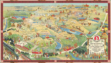
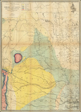
Detailed pocket map of Butte, Montana, showing the original townsite, additional subdivisions, neighboring townships and other fine details.
Highly detailed and unusual map of the area around Butte, Montana. While mining maps of the Butte area appear occasionally on the market, this wall map is one of the earliest maps to focus on townships, subdivisions and other above land features.
This map was prepared by Harper & McDonald, the primary publishers of a the series of Butte maps which began in 1885 and continued f for more than 30 years.
Butte began as a mining town in the 18070s, in the Silver Bow Creek Valley. In 1879, the central business district burned to the ground and the town was thereafter reconstructed from the ground up, using brick and stone.
While initially only gold and silver were mined in the area, the advent of electricity created a massive demand for copper, which was abundant in the area. The resulting boom turned Butte into "the Richest Hill on Earth". Three men fought for control of Butte's mining wealth. These three "Copper Kings" were William A. Clark, Marcus Daly, and F. Augustus Heinze. In 1899, Daly joined with William Rockefeller, Henry H. Rogers, and Thomas W. Lawson to organize the Amalgamated Copper Mining Company. Not long after, the company changed its name to Anaconda Copper Mining Company (ACM). Over the years, Anaconda was owned by assorted larger corporations. In the 1920s, it had a virtual monopoly over the mines in and around Butte.
![Map of Oregon Territory. By Samuel Parker. 1838. [with:] Journal of an Exploring Tour Beyond the Rocky Mountains, under the direction of the A. B. C. F. M. 1840.](https://storage.googleapis.com/raremaps/img/small/97939.jpg)