![[ Siege of Quebec ] Quebek, De Hoofdstad van Kanada; aan de Rivier van St. Laurens . . . 1759 By Isaak Tirion](https://storage.googleapis.com/raremaps/img/small/93087.jpg)


|
||

|

|
|

|
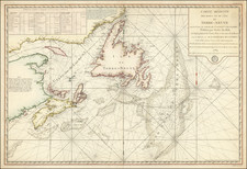
Nice old color example of Tirion's detailed plan of the Siege of Quebec in 1759, at the outset of the French & Indian War (Seven Years War).
Tirion's map is drawn from Englsh sources, and depicts the Siege of Quebec in remarkable detai. The positions of the British and French Fleets are shown, along with the placement of Batteries on either side of the St. Lawrence, with the bombardment of Quebec illustrated. Burning ships can be seen at the mouth of the river, separating the French and English ships.
The locations of troops and ships includes a key noting the major English forces in the battle, including Admiral Holmes, Admiral Sunders, General Monckton, Major Hardy, and General Wolf.
The 1759 Siege of Quebec, also called the Battle of the Plains of Abraham, was an important battle in the French and Indian War. The battle began on September 13, 1759, between the British Army and Navy, and the French Army, on a plateau just outside the walls of Quebec City, on land that was originally owned by a farmer named Abraham Martin, hence the name of the battle.
Following a three-month siege by the British, the actual battle lasted about 15 minutes. British troops commanded by General James Wolfe successfully resisted the column advance of French troops and Canadian military under Louis-Joseph, Marquis de Montcalm. Both generals were killed during the battle.
Isaak Tirion was a prominent Dutch publisher based in Amsterdam in the eighteenth century. He is best known for historical works that included prints showing scenes from around the world. He also produced maps, such as those in the Nieuwe Hand-Atlas of 1744.