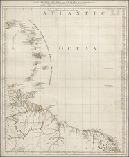
|
||

|

|
|

|
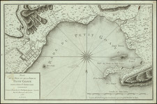
Rare separately issued plan of Havana, as surveyed by Jose del Rio Cosa, Captain of a Frigate of the Royal Armada in 1798 and engraved for Felipe Bauza, one of Spain's most important map and chart makers.
Coming from a recently completed Spanish survey, this chart is perhaps the single most accurate and up to date printed plan of the City and Harbor at the close of the 18th Century.
The map identifies 37 places within the town and harbor of Havana and includes extensive soundings, a city plan and plans of the fortifications around the harbor.
Jose del Rio Cosa's name appears on a number of Caribbean and Florida maps of the period. There is also one reference to his having engaged in the contraband tradebetween Jamaica, Trinidad and Havana, which led to his arrest in 1783. He was involved in a reconaissance of Florida in 1787, when the Royal Official of Cuba, Francisco Javier de Morales, was ordered to sponsor an expedition to East Florida to determine the feasibility of developing the timber and naval stores industries in the Peninsula for the Havana Naval Arsenals.
As a large format Spanish printed map of a Colonial Harbor, this chart is of great interest. The Spanish policy of secrecy with respect to geographical information dominated Spain's informational policies for over 200 years. As a result, there were very few printed maps of the Spanish colonies published prior to 1770 and the few that were published were often highly edited to eliminate military and topographically useful details. It was not until the final quarter of the 18th Century when this policy was relaxed and the troves of information coming from the Spanish military surveys was available for publication, albeit limited to the very few officially sanctioned mapmakers, such as Bauza.
Felipe Bauza (1764 - 1834) was a Spanish soldier, politician, mapmaker and astronomer. One of his most important early map making projects was as the mapmaker for the Malaspina expedition of 1788, resulting in the naming of an island in New Zealand (Bauza Island or Island of the Mosquitos). During the Peninsular War, he is famous for refusing to turn over his map collection to Napoleon's Army, instead felling to Cadiz. IN 1815, he was appointed director of the Spanish Hydrographical Office and was part of the commission which created the maritime Atlas of Spain.
The map is apparently quite rare on the market, with no examples being offered on the market in AMPR. We note examples at the John Carter Brown, Harvard, Huntington Library and Texas Historical Society in the United States.