|
||

|

|
|

|
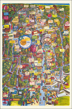
Rare early map of Corona California, oriented with south at the top, showing the original proposed layout of the town.
The map was originally published shortly after its initial creation in 1886 and prior to its incorporation as the City of Corona. The circular area in the center is now Corona's city center. The map identifies early railroad lines, streets, early subdivisions and other details. In red, there are Pacific Electric Railway Company annotations, showing the Southern Pacific Railroad's acquisitions of certain lands (likely the right of way for the railroad, shown in red) in 1896 and additional information dated 1915.
The map is extremely rare. OCLC locates no examples of this map, although a variant edition of Kellogg's map, published in San Francisco by Renshaw Litho., is shown. The Huntington lists a copy of the present map, the only copy we could find.
Corona, founded at the height of the Southern California citrus boom in 1886, is situated at the upper end of the Santa Ana River Canyon, the only significant pass through the Santa Ana Mountains. The town of Corona once laid claim to the title "Lemon Capital of the World." The city derived its name (and its nickname, The Circle City) from the curious layout of its streets, with a standard grid enclosed by the circular Grand Boulevard, one mile in diameter. The street layout was designed by Hiram Clay Kellogg, a civil engineer from Anaheim who was an influential figure in the early development of Orange County.
The origin of the city was in May, 1886, when the South Riverside Land and Water Company was incorporated, its members including ex-Governor of Iowa, Samuel Merrill, R.B. Taylor, George L. Joy, A.S. Garretson, and Adolph Rimpau, as a citrus growers' organization, it purchased the lands of Rancho La Sierra of Bernardo Yorba, and the Rancho Temescal grant and the colony of South Riverside was laid out. They also secured the water rights to Temescal Creek, its tributaries and Lee Lake. Dams and pipelines were built to carry the water to the colony. In 1889 the Temescal Water Company was incorporated, to supply water for the new colony. This company purchased all the water-bearing lands in the Temescal valley and began drilling artesian wells.

![[Imperial & Coachella Valley Advertising Map -- Valerie Jean Date Shop]](https://storage.googleapis.com/raremaps/img/small/69651.jpg)