This item has been sold, but you can enter your email address to be notified if another example becomes available.


|
||

|

|
|

|
Stock# 31496df
Description
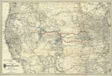
Detailed map of Long Beach, California, privately prepared by the Atchison Topeka & Santa Fe Railroad for internal usage.
The map identifies the city boundaries, early streets of Long Beach California, shortly after its incorporation in 1897. An unnamed park and pier appear near the bottom cener and the lines of the Santa Fe Railroad are shown.
Condition Description
Minor discoloration along folds. Printed on waxed linen.
![(California Oil Fields) [15 original photographs of Tupman Lease oil derricks and oil facilities at Taft, Kern County, California]](https://storage.googleapis.com/raremaps/img/small/94701.jpg)
![[ One of the First Printed Views of California ] A Remarkable Mountain near the River of Monterrey](https://storage.googleapis.com/raremaps/img/small/88071.jpg)