|
||

|

|
|

|
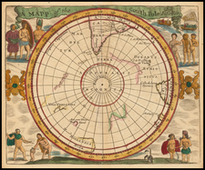
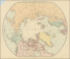
Fine example of Philippe Buache's map of the Eastern Hemisphere, based upon an earlier map by Guillaume De L'Isle, with substantial revisions.
The map is perhaps most notable for the renewed speculation regarding lands of the southern polar regions. Still entirely undiscovered, French map makers had taken a renewed interest in the prospects of the lands of the unknown southern continent in the middle part of the 18th Century. For example, the present map shows "Terre de Goneville" a reference to the discovery of Antarctica by a French explorer named Gonneville in 1504. The French explorer Captain Binot Paulmyer de Gonneville claimed to have discovered the southern continent in 1504. He stayed six months and found the natives "asked nothing but to lead a life of contentment, without work." He brought back skins, ornaments, and an Indian prince named Essomeric. Historians believe that Gonneville was probably in southern Brazil.
In the interior of the imagined southern continent, Buache postualates a large Antarctic Sea, which was inspired in part b the 1738-9 expedition of Bouvet de Lozier, which mentions the discovery of icebergs between two and three hundred feet high and half a league to two or three leagues in circumference. Buache placed Bouvet's Cap de la Circoncision at 54° south, below Africa, a northern promontory of the smaller of his two land masses, next to one of the openings of his polar sea, where Bouvet had recorded his many great icebergs. Buache also shows the route of the voyage of Abel Tasman (1603-1659) in 1642-3 as a source for information about the southern lands. Buache believed that the icebergs must have derived from a floating ice sheet, as in the Arctic, rather than from the newly discovered land. This led him to conclude that the southern continent was not a single landmass but two islands separated by a frozen inland sea, from which icebergs detached themselves to float northwards.
The sea shown in the center of Antarctica was based upon a hypothesis Buache had developed over a number of years. His paper 'Geographical and physical observations, including a theory of the Antarctic regions and the frozen sea which they are supposed to contain' was published by The Gentleman's Magazine in 1763. In it, he hypothesised that the southern pole must contain a frozen sea, fed by mountain ranges and huge rivers, in order to produce icebergs of the size reported by Bouvet; the large sea (Mer Glacial, 'Glacial Sea') depicted on the 1739 map is an early version of this hypothesis.
Buache was an academic geographer who researched his material thoroughly, relying on the most up-to-date information from voyages of discovery. He was the first geographer to recognize the important concept of the watershed and it was this that led him to make a number of deductions, some correct, some not. A correct deduction was the existence of Alaska and the Bering Strait, years before they were officially discovered, while an incorrect deduction was the existence of a central Antarctic sea, which he conjectured to be the source of the icebergs observed by Bouvet in 1738-39.
There are those, including Hapgood, who see Buache's map as a tie in to the Piri Reiss map in the argument that these maps depict a subglacial land mass that is the Antarctic.
Philippe Buache (1700-1773) was one of the most famous French geographers of the eighteenth century. Buache was married to the daughter of the eminent Guillaume Delisle and worked with his father-in-law, carrying on the business after Guillaume died. Buache gained the title geographe du roi in 1729 and was elected to the Academie des Sciences in the same year. Buache was a pioneering theoretical geographer, especially as regards contour lines and watersheds. He is best known for his works such as Considérations géographiques et physiques sur les découvertes nouvelles dans la grande mer (Paris, 1754).