


|
||

|

|
|

|
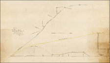
Rare early map of the Yosemite Valley by A.L. Bancroft, which utilizes the Whitney map of 1865, and Hoffman corections of 1868 as a base map, but adds significant new information which does not appear on earlier maps.
The map was prepared by Bancroft at the beginning of a period of great commercial expansion in the Valley, for which Bancroft prepared a number of other publications.
The following is a list of significant new features added by Bancroft: Inpsiration Point is named, there are revised locations for Leidig's Hotel and Black's Hotel (each of which is moved further east), Kachoomah Fall and Snow's Hotel below Little Yosemite Valley, and Panorama Rock in Little Yosemite Valley. indian names for many of the natural features located on the map. The location of the "New Trail" along the north rim of the Valley, which drops into the Valley east of Yosemite Falls and then ascends into Little Yosemite Valley, before turning west and following the rim of the Canyon to Sentinel Dome, then turning southwest and dropping off the map, then re-appearing below Inspiration Point and again following the south rim of the valley.
Below is a summary of the early history of the map.
Bancroft's map is based directly on the map of Yosemite produced during Whitney's California Survey. In 1864 the governor of California accepted Yosemite as land to be owned by the State. King, Gardner, and Cotter, were ordered immediately to complete a survey of Yosemite before the onset of winter. Despite unusually bad weather, the group produced a superb early map of the Valley.
In 1865, the first of the Whitney Survey maps of Yosemite was published. Thereafter, the map was revised on several occasions, most notably including a 3rd edition in 1870, which appeared in J.D. Whitney's Yosemite Guide-Book (1870), and which included significant improvements as noted below.
The original survey of Yosemite Valley by King and Gardner was paid for by Frederick Law Olmsted in the hopes of later reimbursement from the State. There was some urgency to the mapping survey because winter was imminent. King concentrated on the cliffs and sketched the floor of Yosemite Valley very roughly, almost as an afterthought. In 1867, Charles F. Hoffmann was sent to map the valley floor with particular reference to private claims and developments there. In comparing his map with King and Gardner's earlier map, he discovered that the two maps did not correspond. Whitney declared King's work "a complete sham" and was determined to correct it for the next edition of the guidebook.
While the Yosemite Valley map was drawn in 1865 by Gardner, it was not published in any form until 1868 in the Geological Survey of California, J. D. Whitney, The Yosemite Book (New York: Julius Bien, 1868) (Farquhar 7a). In addition to Watkins' and Harris' photographs of the Yosemite Valley and region, this publication had two folding maps attached to the endsheets at the back of the volume. One was a map of the high Sierra adjacent to Yosemite Valley and was surveyed in 1863-1867, by Hoffmann and Gardner. The second was the map of Yosemite Valley, printed in this first edition with a green overprint for the meadows. In the 1872 map, Bancroft has copied the green overnprinting.
The Yosemite Guide-Book published in 1868 (Farquhar 7b), had woodcuts instead of photographs. In pockets in both the front and back boards were the maps of Yosemite Valley and the high Sierra. The map of Yosemite Valley was unchanged from the first printing, except that there was no green overprint. The second edition of the Yosemite Guide-Book was published in 1870 (Farquhar 7c). Again, pockets in both the front and back boards contained the maps of Yosemite Valley and the high Sierra. The map of Yosemite Valley in this edition is the version corrected from Hoffmann's mapping of the valley in 1867. The river is shown correctly, along with the Yosemite Creek fan below the falls. Buildings, roads, and orchards have also been added.
A full size, revised and updated version of the Yosemite Valley map was apparently issued about 1874, on heavy paper. This version was never issued with a publication, though sections of it were no doubt used for smaller, pocket-sized versions. Hoffmann's manuscript map of Yosemite Valley, and the 1870 corrected version from it, are reproduced digitally in the Octavo (Octavo.com) version of Whitney's The Yosemite Book (1868; 2003), along with the original 1868 version.
The map was de-accessioned from the Connecticut State Library in 2012. OCLC locates only 1 copy (Bancroft Library, UC Berkeley).
![[ Highway Symbols! ] Automobile Road Map of California-Nevada Los Angeles and Vicinity Long Beach](https://storage.googleapis.com/raremaps/img/small/99652.jpg)
![[Santa Cruz & Santa Clara Counties] Denny's Pocket Map of Santa Cruz County, California. Compiled From the Latest and Official Data . . . `1916](https://storage.googleapis.com/raremaps/img/small/80637.jpg)