|
||

|

|
|

|
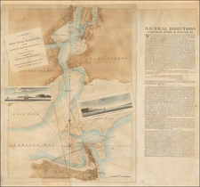
Rare Le Rouge edition of Scull & Heap's seminal Philadelphia map, which was issued by the French at the commencement of the American Revolution, as part of an atlas prepared for the French Military for use in aid of the American Colonists.
When first issued in 1752, the famous Scull and Heap plan was intended to promote William Penn's new city on the Delaware. When the events of the American Revolution began to heat up, illustrations of the center of the revolt, Philadelphia, began to be in great demand in Europe. This demand was soon met by publishers in England, Germany and France with the reissue of the Scull and Heap map, still the most up-to-date cartographic treatment of Philadelphia then available.
Holmes' grid plan for the city is shown, situated between the rivers, and numerous outlying 'country seats' are placed and named, with the primitive road system also indicated. Lotter updated from the first edition to take into account the changes in the place names and environs of the City since the middle of the Century, and Heap's elevation of the statehouse was moved from the top to the bottom center of the plate. The result of all this is a highly attractive and historic map that shows Philadelphia at the time of the Revolution.
The maps was included in Le Rouge's rare North American Pilot, an atlas of Sea Charts compiled by the French Government and utilized by the French Navy during their participation in aid of the Americans during the American Revolutionary War. A fine wide margined example of this scarce French Naval Chart.
The map is very rare on the market, much rarer than the Faden and Lotter editions of the map.
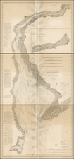
![[A chart of New York Island & North River: East River, showing passage through Hell Gate, and the North Shore of Long Island: Flushing Bay, Hampstead Bay, Oyster and Huntington Bay, Cow Harbor]](https://storage.googleapis.com/raremaps/img/small/51531.jpg)