|
||

|

|
|

|
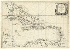
Rare French edition of William Fuller's rare chart containing the soundings and navigational information surrounding Amelia Island and the mouths of the Nassau River and St. Mary's River in Florida, prepared for use by the French Navy during the American Revolution.
The natural deep harbor on the north end of Amelia Island was an important anchorage for all kinds of sailing vessels including smugglers, pirates, and slave ships. The two charts on the right were made from surveys of Captain William Fuller. The plan of Amelia Island is noted as being taken from William De Brahm's monumental large format map of South Carolina & Georgia, published in 1757. A prospective view of the entrance to St. Mary's River is inset at upper right. Dedicated to the Right Honorable John Earl of Egmont.
The largest map, A Chart of the Entrance into St. Mary's River, features the northern end of the island and the waterway that runs in between it and Cumberland Island, Georgia. The plan note numerous depth soundings and the locations of the shifting shoals that posed a great threat to mariners. The map also illustrates the "New Settlement," with its ordered grid of streets planned by the British, shown near the northern tip of Amelia Island.
Across the river on Cumberland Island, the ruins of the abandoned Fort William are depicted. Founded in the 1740s by Georgia governor James Oglethorpe, the Fort was built to guard the southern approaches of the colony from the Spaniards, who were based in nearby St. Augustine. This map also features a fine navigator's view of the entrance of the river, in the upper right corner.
The map below, A Chart of the Mouth of the Nassau River, shows a significant amount of hydrographical information, along with sailing instructions for mariners. The chart shows the waterway that runs past the southern tip of Amelia Island, in between it and Talbot Island. It is today the location of the main shipping lane leading into the port of Jacksonville.Amelia Island is located on the boundary between Florida and Georgia.
The chart was included in Le Rouge's rare North American Pilot, an atlas of Sea Charts compiled by the French Government and utilized by the French Navy during their participation in aid of the Americans during the American Revolutionary War. A fine wide margined example of this scarce French Naval Chart.
George-Louis Le Rouge (1712-1790), though known for his work in Paris, was originally born Georg Ludwig of Hanover, Germany. He grew up and was educated in Hanover, after which he became a surveyor and military engineer. Around 1740, however, Le Rouge moved to Paris and set up shop as an engraver and publisher on the Rue des Grands Augustins. It was at this time that he changed his name, adopting a French pseudonym that would later become quite famous.
Le Rouge spent much of his forty-year career translating various works from English to French, and his cartographic influence often came from English maps. His experience as a surveyor and engineer in Germany made him a skilled and prolific cartographer, and he produced thousands of charts, maps, atlases, and plans. His work spans from garden views and small-town plans to huge, multiple-continent maps. Le Rouge eventually accepted the position of Geographical Engineer for Louid XV, the King of France.
Later in life, Le Rouge became well-known for publishing North American maps, such as in his Atlas ameriquain septentrional of 1778. One of Le Rouge’s other more famous works is the Franklin/Folger chart of the Gulf Stream, which he worked on with Benjamin Franklin. Franklin and Le Rouge corresponded around 1780 and collaborated to create this map, a French version of Franklin’s famous chart which was originally printed in 1769.
![[ Florida Indians - King Outina Consulting a Sorcerer ] Outina adversus hostem exercitum ducens, de eventu Magum consulit. XII.](https://storage.googleapis.com/raremaps/img/small/97101.jpg)