|
||

|

|
|

|
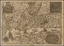
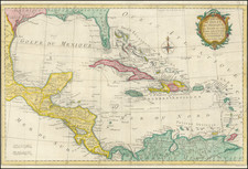
Fine example French edition of the first edition of Thomas Jefferys map of Florida and the Gulf Coast, prepared for his Pilote Americain Septentrionale, which was compiled specifically for use by the French Navy during the American Revolution.
The map one of the earliest large format French maps to treat the region with such remarkable detail, including soundings and rhumblines. The map follows the first edition of Jeffery's map, which was significantly revised in a second edition of 1775. The detail in Florida and the Bahamas is excellent as is the elaborate compass rose and sailing ships.
Le Rouge's chart would have been one of the primary sources of information for French Military Pilots and French Merchants in route to America to support the Colonists against Great Britain duing American Revolution.
Following the commencement of the American Revolution, France initially played a passive support role on behalf of the American colonists. While some important French officers, including Lafayette and Pierre L'Enfant joined the Americans as volunteers, for the first two years, the French primarily provided military and other supplies to the Americans. Ultimately, in 1778, following several years of diplomatic efforts by Benjamin Franklin and others, France formally recognized the United States on February 6, 1778, which was followed shortly thereafter by Britain's declaration of war on France on March 17, 1778.
France's initial involvement in the war in North America was an unsuccessful attempt to capture Newport, Rhode Island, which was then under British occupation.
In support of France's new military interests in North America, George Louis Le Rouge, then mapmaker to King Louis XVI, set out to create a set of sea charts of North America for use by the French Navy. Le Rouge's Pilote Americain Septentrionaledrew upon the work of William Faden and Thomas Jefferys, utilizing a series of maps first published in 1775 under the title North American Pilot, which consisted of 2 volumes, one focusing on Canadian waters and the second focusing on what would become the 13 Colonies. The maps were modified with French nomenclature and sailing directions and improved where better information was available.
Because its primary purpose was as a military atlas designed for use at sea by the French Navy, very few examples of the Pilote Americain Septentrionale have survived, even fewer in good condition, and the individual maps from this atlas rarely appear on the market. The last complete copy of the atlas to appear at auction was sold at Sothebys in 1949.