


|
||

|

|
|

|
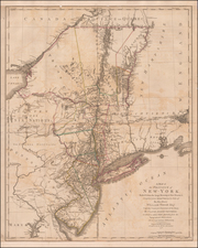
Important early Revolutionary War map of New York, published one day prior to the signing on the Declaration of Independence.
The map was published by William Faden and appears in his very rare North America Atlas. Shows New York, Long Island, New Jersey and parts of Pennsylvania, Maryland and southern New England, based upon the actual surveys by C.J. Sauthier, with New Jersey added from the topographical observations of Sauthier and Ratzer. Includes Martha's Vineyard, Long Island, Boston, northern Chesapeake Bay, Annapolis and extends north to show Montreal.
A fascinating and detailed look at the towns, villages, military posts and forts, manors, roads, churches, rivers and ferries at the beginning of the Revolutionary War. Locates Dartmouth College and settlements along the Connecticut River. Features the disputed line of partition between New York and New Jersey and early county boundaries in New York.
An important Revolutionary War erea amp of the Northeast.
![[ English Plantations in North America ] A New Map of the most Considerable Plantations of the English In America Dedicated to His Highness William Duke of Glocester.](https://storage.googleapis.com/raremaps/img/small/98233.jpg)
![Carte Particuliere de Virginie, Maryland, Pennsilvanie, La Nouvelle Jarsey. Orient et Occidentale [Heighten in Gold!]](https://storage.googleapis.com/raremaps/img/small/61392mp2.jpg)
![[Revolutionary War Plans of New York, Boston, Charleston, Delaware River to Philadelphia & Havana] Various Plans and Draughts of Cities, Towns, Harbours &c . . .](https://storage.googleapis.com/raremaps/img/small/83450.jpg)
![[ Middle British Colonies Map ] Pensilvania Maryland and Virginia](https://storage.googleapis.com/raremaps/img/small/98228.jpg)