|
||

|

|
|

|
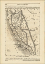
Detailed map of Southern California, focusing on the location of the various Southern California Spanish & Mexican Ranchos and survey lines of the General Land Office, centered on the San Bernardino Baseline and
The map is from the archives of the Southern Pacific Railroad and was likely utilized as a general overview map showing the locations of the various towns nd Ranchos around the City of Los Angeles, extending to the San Gabriel Mountains, Malibu and Rancho Conejo, Palos Verdes and Rancho San Jose and the Pomona area.
The map also includes the names of some of the larger land owners in the region and some of the early subdivisions. Some of the more interesting places located are the Los Angeles Farming and Milling Company (founded 1880 by James B. Lankershim), the Porter Land & Water Company, Santa Gertrude's Land Association, Cerritos Beet Sugar Co.
The map would seem to pre-date 1905, as there is no mention of Beverly Hills and no indication that the railroad line to Chatworth extends beyond Chatsworth toward the Santa Susanna Tunnell, which was constructed prior to 1904.
This is one of the best general overview maps of the area we have encountered. Large format maps showing the early Ranchos of Southern California are very rare on the market.