|
||

|

|
|

|
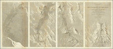
Breaking the Monopoly on Transcontinental Links to the Pacific Coast
Early copy of this highly important map of the southwest prepared by William Raymond Morley during the so-called Royal Gorge Railroad War in Colorado.
During the 1870s, the mining regions of Colorado were among the most productive in America and there was tremendous interest among Western Railroads capture portions of the supply lines to the mining regions. One of the most important mining regions in Colorado was Leadville. The Atchison Topeka & Santa Fe Railroad (Santa Fe) sought to capitalize on the need to supply the mining towns of Colorado and northern New Mexico with food, equipment, and other supplies. To exploit this opportunity, the Santa Fe sought to extend its route westward from Pueblo along the Arkansas River, and through the Royal Gorge in 1877.
Royal Gorge was a bottleneck along the Arkansas River which was too narrow for both the Santa Fe and the Denver and Rio Grande Western Railroad (DRG) to pass through, and there was no other reasonable access to the South Park area. As a result, a race ensued to build rail access through Royal Gorge. Physical confrontations led to two years of armed conflict, essentially low-level guerrilla warfare between the two companies that came to be known as the Royal Gorge Railroad War. Federal intervention prompted an out-of-court settlement on February 2, 1880 in the form of the so-called "Treaty of Boston" wherein the DRG was allowed to complete its line and lease it for use by the Santa Fe. The DRG paid $1.4 million to Santa Fe for its work within the Gorge and agreed not to extend its line to Santa Fe, while the Santa Fe agreed to forgo its planned routes to Denver and Leadville.
To the south, as part of its plan, the Santa Fe authorized a $20,000 initial expenditure on February 26, 1878 for the construction of a rail line south fromTrinidad, Colorado, in order to "..seize and hold Raton Pass." The location of the route was nearly as crucial to the venture's success as was the actual track construction. William Raymond Morley, a former civil engineer for the DRG, who had been hired by the ATSF in 1877, was given his first assignment to secretly plot a route through the pass. At the time, the Santa Fe it was feared that any activity in the area would lead the DRG to construct a narrow gauge line over the Pass. Additionally, Santa Fe officials learned that the Southern Pacific Railroad (SP) had introduced legislation to block the Santa Fe's entry into New Mexico. To protect its position, the Santa Fe obtained a charter for the New Mexico and Southern Pacific Railroad Company and immediately sent A. A. Robinson to Raton Pass. From February to December 1878 work crews struggled to build the line between La Junta and Raton, and the first Santa Fe train entered New Mexico on December 7, 1878, at the height of the Royal Gorge Railroad War.
The purpose of this copy was apparently to outline the routes (in red) of the lines of the railroad through New Mexico and Arizona, extending west to Maricopa Wells (just south of Phoenix). Because of the secrecy associated with the original reconnaissance conducted by Morley, it is unlikely that any copies of the original map and reconnaissance were available to the public and likely that only a few copies were ever produced, making this copy an artifact of great importance.
We found only one on line contemporary reference to the line. The Arizona Silver Belt, Decemer 20, 1876 notes:
Mr. W. R. Morley, who has had charge of the preliniinary survey of the New Mexico & Southern Pacific branch of the Atchison, Topeka & Santa Fe Railroad, from Trinidad to Fort Yuma, gives us some interesting points regarding the work. The line will be an exceedingly easy one to construct, there being few grades beyond Albuquerque to exceed forty feet to tne mile, and most or them not over twenty feet. The country through which the line runs is mostly mining and pastoral, with but a small area suitable for agricultural purposes. The general appearance of the country is similar to that of Southern Colorado, but there is less water. The Southern Pacific Railrroad Company will be likely to extend their road during the coming winter east as far as Maricopa Wells one hundred and sixty-five miles from Fort Yuma and possibly to Tucson, a distance of two hundred and fifty miles. That company is in good financial condition and able to push forward to meet the Atchison, Topeka & Santa. Fe at any time.
Rarity
We were unable to locate any examples or references to the map or the reconnaissance in any public records or in any on line record or database.
This copy of the map (and a full sized blue-print copy of the map with an additional key and some manuscript annotations) were de-accessioned from the records of the Santa Fe Railroad in the 1980s, and acquired by one of its then surveyors, who kept it until it was sold to Barry Lawrence Ruderman Antique Maps in July 2012.