This item has been sold, but you can enter your email address to be notified if another example becomes available.


|
||

|

|
|

|
Stock# 31178
Description
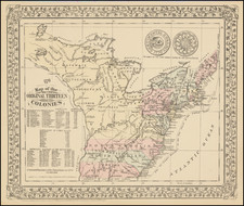
Large map showing the progress of the Railroad in the eastern and central parts of the United States up to 1849.
Outline map of the eastern half of the United States indicating drainage, state boundaries, major cities, and constructed and contemplated railroads. The southern portion of map indicates proposed shipping routes to points in the West Indies and Middle America. This is one of the earliest government maps of the entire US to show the national railroad network.
![[Shows Franklinia!] Charte Der XV Vereinigten Staaten von Nord-America Nach Murdochischer Projection . . . F.G. Gussefeld . . . 1804](https://storage.googleapis.com/raremaps/img/small/91386.jpg)
![[ Wyoming Attached To Dakota Territory ] The United States of America](https://storage.googleapis.com/raremaps/img/small/99363.jpg)