


|
||

|

|
|

|
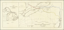
First edition of Peck & Messenger's map of Illinois and part of Wisconsin Territory, published by Doolittle & Munson in Cincinnati.
Peck and Messenger were early residents of the Illinois, who created one of the earliest maps of the state published west of the Alleghany Mountains and one of the earliest separately published maps to focus on the State of Illinois. This is also one of the earliest appearances of the name Wisconsin on a printed map (along with Doolittle & Munson's map of M ap of the surveyed part of Wisconsin Territory: compiled from public surveys as returned to the Surveyor General's Office) pre-dating the Congressional Act which created Wisconsin Territory (April 20, 1836) and apparently the first privately printed map to use the name Wisconsin (appearing in the same year as Farmer's Improved Map of the Territories of Michigan and Ouisconsin).
Among other features, the map includes a vignette of llinois College, the first college in the state, which was founded by Peck. Chicago is the only settlement in the norther part of the state.
The map also references an Indian Battle fought on the Wisconsin River in 1832. This is a reference to a battle fought in Wisconsin in 1832. After the Fox and Sauk tried to prevent a village in Illinois from being taken by white settlers, the Indians were pursued north into Wisconsin. The few skirmishes there became known as the Black Hawk War. That war also ended with the defeat of the Indians, and is perhaps most famous because Abraham Lincoln served as a young volunteer soldier, although he later said that the only fighting he did was with the mosquitos.
The present map pre-dates the issuance of Peck & Messenger's A New Sectional Map of the The State of Illinois, published in New York by J.H. Colton and first issued in 1836. A second and slightly enlarged edition was published by Grigg and Elliot in Philadelphia in 1837 and appeared in Peck's A Gazeteer of Illinois. It is also apparently the only edition of the map published in Cincinnati. The map is one of the first by Samuel Bishop Munson. Doolittle & Munson first advertised their services as engravers and copper-plate printers in the Cincinnati Directory Advertiser for 1831.
The map is apparently quite rare on the market. We note no dealer records in AMPR and only 1 record in Americana Exchange (Goodspeed Catalog 204-846, 1931, priced at $10.00).
John Mason Peck (1789-1858) was and American Baptist Missionary, who would go on to become one of St. Louis's leading citizens. In the 1820's, he founded one of the first Protestant churches west of the Mississippi, the first college in Illinois, and ordained the first African-American clergy in St. Louis. He also established the first schools for slaves in St. Louis. He was a great publicist for the region and encouraged settlement back east through his famous gazetteer for Missouri and Illinois, and wrote many other books which celebrated the pioneer spirit and history of the area.
John Messinger (1771-1846), was an early settler at Clinton Hill, Illinois (St. Clair County), two and a half miles north of Belleville, kept the first post office in the county outside of Cahokia. Messinger was an accomplished surveyor and surveyed a large portion of the land in this and adjoining counties. In 1783 he removed to Vermont and learned the carpenter's trade and also became a millwright. He came to Kentucky in 1799, and from there to New Design, where he lived a few years and then settled permanently at Clinton Hill.
Beginning in 1806, Messenger was one of the surveyors to survey a portion of the future state of Illinois into townships. He surveyed much of the public domain in both St. Clair and Randolph Counties. He wrote and published in 1821 a book entitled, A Manual or Hand-Book of Practical Surveying. Messenger first encountered John Mason Peck at Dr. Peck's Seminary at Rock Spring. In 1815, he was made a deputy under the Surveyor-General of Ohio, with authority to survey the military tract in the forks of the Mississippi and Illinois Rivers. Later he was appointed to assist in the survey of the northern limits of Illinois, and he made a part of the astronomical and mathematical calculations by which the line dividing the states of Illinois and Wisconsin was located.
Messenger and Philip Creamer made surveyors' compasses that were as well calculated and as well finished in workmanship as any made in the United States. Messenger was a member of the convention that met at Kaskaskia and framed the first constitution of Illinois. He was also a member of the first general assembly of Illinois, which convened in 1818, and on its organization was elected speaker of the House of Representatives.
John Mason Peck (1789-1858) was and American Baptist Missionary, who would go on to become one of St. Louis's leading citizens. In the 1820’s, he founded one of the first Protestant churches west of the Mississippi, the first college in Illinois, and ordained the first African-American clergy in St. Louis. He also established the first schools for slaves in St. Louis. He was a great publicist for the region and encouraged settlement back east through his famous gazetteer for Missouri and Illinois, and wrote many other books which celebrated the pioneer spirit and history of the area.
John Messinger (1771-1846), was an early settler at Clinton Hill, Illinois (St. Clair County), two and a half miles north of Belleville, kept the first post office in the county outside of Cahokia. Messinger was an accomplished surveyor and surveyed a large portion of the land in this and adjoining counties. In 1783 he removed to Vermont and learned the carpenter's trade and also became a millwright. He came to Kentucky in 1799, and from there to New Design, where he lived a few years and then settled permanently at Clinton Hill.
Beginning in 1806, Messenger was one of the surveyors to survey a portion of the future state of Illinois into townships. He surveyed much of the public domain in both St. Clair and Randolph Counties. He wrote and published in 1821 a book entitled,A Manual or Hand-Book of Practical Surveying. Messenger first encountered John Mason Peck at Dr. Peck's Seminary at Rock Spring. In 1815, he was made a deputy under the Surveyor-General of Ohio, with authority to survey the military tract in the forks of the Mississippi and Illinois Rivers. Later he was appointed to assist in the survey of the northern limits of Illinois, and he made a part of the astronomical and mathematical calculations by which the line dividing the states of Illinois and Wisconsin was located.
Messenger and Philip Creamer made surveyors' compasses that were as well calculated and as well finished in workmanship as any made in the United States. Messenger was a member of the convention that met at Kaskaskia and framed the first constitution of Illinois. He was also a member of the first general assembly of Illinois, which convened in 1818, and on its organization was elected speaker of the House of Representatives.

![[Eastern Sheet -- Ohio] Post Road Map of the States of Ohio and Indiana with Adjacent Parts of Pennsylvania Michigan Illinois Kentucky and West Virginia Showing Post Offices With The Intermediate Distances and Mail Routes In Operation On the !st of February 1885 . . .](https://storage.googleapis.com/raremaps/img/small/44153.jpg)
