|
||

|

|
|

|
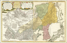
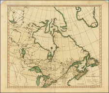
Eastern sheet Wilbrecht's a rare 3-sheet map of the Russian Empire, depicting Alaska, the Northwest Coast of America and the West Coast of Canada, prior to the discovery of Vancouver Island, along with Kamchatka, Northeast Russia and Iezo.
The map is one of 3 sheets from an extremely rare map entitled: Carte generale de l'Empire de Russie divise en quarante et un gouvenemens. The map would appear to be an updated French language edition of Wilbrecht's Generalniia karta Rossiiskoi Imperii na sorok odnu guberniiu razdelennoi, which appeared in his Rossiiskoi Atlas, first published in 1792.
The references located for this map were in the collections of the Private Library of Her Majesty, the Queen of Denmark, Christianbourg Castle, in Copenhagen (National Archives) and Yale. The map appears without attribution to a mapmaker and is dated ca 1800 in Sources of the History of North Africa, Asia and Oceania in Denmark, 1980. The Yale copy provides a longer title, which likely gives important information as to the source of the map, Alexander Wilbrecht. The full title given by Yale is:
Carte générale de l'empire de Russie divisé en quarante et un gouvernemens. Redigée en 1800. Comp: par Alexandre Vilbrekht.
Based upon the foregoing, we have attributed the map to Alexander Wilbrecht, but it is also possible that it was published by an anonymous French publisher, relying upon the work of Wilbrecht. The lack of a publisher name or location makes it difficult to determine the place of publication.
Alexander Wilbrecht (1757-1823) was a mathematician, geographer, cartographer and astronomer. Wilbrecht served as Geographer of The Geographic Department of the Cabinet of Her Imperial Majesty. In 1782, he produced the first Russian atlas. He also produced a number of important separately issued maps between 1787 and 1802. Wilbrecht is credited with authorship of several atlases, including Ross'iiskoi Atlas iz soroka chetyrekh kart sostaiashch'ii I na sorok na dva namiestnichestva Imper'iiu razdieliaushch'ii. [The New Atlas or a Collection of all parts of the Globe], St. Petersburg, 1793 (Philips 679). Wilbrecht created several maps of the region depicted in the present map, including the following two maps:
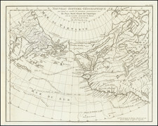
The map depicts the Northwest Coast of America, following the explorations of Dixon and Portlock. However the primary Russian source material was almost certainly contemporary Russian information.