|
||

|

|
|

|
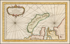
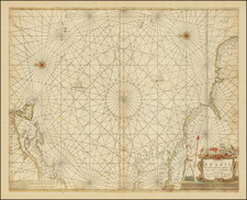
Unrecorded proof state of Jodocus Hondius II map of the Straits of Magellan, Le Maire Strait, Fire Lands and the southern tip of Patagonia.
The map is not to be confused with the later and completely revised map of the Straits of Magellan, published by Henricus Hondius beginning circa 1630. Following the death of the Jodocus Hondius I in 1612, the Mercator-Hondius atlas was published by Henricus Hondius. During this time, Jodocus Hondius II engraved a number of new map plates for his own atlas, but ultimately sold the plates to Willem Blaeu.
The present example of the map is a previously unrecorded proof state by Jodocus Hondius II, which pre-dates the exceedingly rare first state of the map, which was later sold to Blaeu, who added his name to the plate and removed the name of Jodocus Hondius (see link below):
As can be seen in comparing the the two maps, the proof state does not include the text annotation to the left of the Patagonian man below the compass rose, lacks the rings aroung the two sets of text annotations below and to the left of the compass rose, lacks the mountains above and to the right of the compass rose and lacks the mountains to the right of the Notitia cartouche.
By contrast, the changes from the known early state (and Blaeu plate) to the more commonly seen Henricus Hondius map are quite significant. The west side of Tierra del Fuego and regions above are shown as small islands, rather than the ambiguous forms used in the later Hondius map. The notes in the center of the map are contained in small circles in the earlier edition and a massive Patagonian is shown next to a smaller European man at the bottom center, alon with two see lions. Nassauvsche Voerd and Lheremitens Eylandt and Cape Horn appear on the later edition of the map only, whereas no island or strait above Cape Horn appears in the early edition. The contours of the southern coastline are also completely different. The placement of the compass rose is also moved.
A link to the later edition can be found here: /gallery/detail/30162
Both the proof state and first edition of the map is of the quite rare. We have located at least 1 other example of the proof state in a composite atlas, but prior to June 2012, the proof state was apparently unrecorded.
Jodocus Hondius the Elder (1563-1612), or Joost de Hondt, was one of the most prominent geographers and engravers of his time. His work did much to establish Amsterdam as the center of cartographic publishing in the seventeenth century. Born in Wakken but raised in Ghent, the young Jodocus worked as an engraver, instrument maker, and globe maker.
Hondius moved to London in 1584, fleeing religious persecution in Flanders. There, he worked for Richard Hakluyt and Edward Wright, among others. Hondius also engraved the globe gores for Emery Molyneux’s pair of globes in 1592; Wright plotted the coastlines. His engraving and nautical painting skills introduced him to an elite group of geographic knowledge seekers and producers, including the navigators Drake, Thomas Cavendish, and Walter Raleigh, as well as engravers like Theodor De Bry and Augustine Ryther. This network gave Hondius access to manuscript charts and descriptions which he then translated into engraved maps.
In 1593 Hondius returned to Amsterdam, where he lived for the rest of his life. Hondius worked in partnership with Cornelis Claesz, a publisher, and maintained his ties to contacts in Europe and England. For example, from 1605 to 1610, Hondius engraved the plates for John Speed’s Theatre of the Empire of Great Britaine.
One of Hondius’ most successful commercial ventures was the reprinting of Mercator’s atlas. When he acquired the Mercator plates, he added 36 maps, many engraved by him, and released the atlas under Mercator’s name, helping to solidify Mercator’s reputation posthumously. Hondius died in 1612, at only 48 years of age, after which time his son of the same name and another son, Henricus, took over the business, including the reissuing of the Mercator atlas. After 1633, Hondius the Elder’s son-in-law, Johannes Janssonius, was also listed as a co-publisher for the atlas.
![[ Acapulco and Environs ] Disposition des Vaisseaux de l'Escadre commandee par Mr. Anson croisant, vis a vis d' Acapulco en 1742](https://storage.googleapis.com/raremaps/img/small/98783.jpg)