


|
||

|

|
|

|
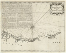
The First English Sea Chart of South America and Georgia.
Scarce early sea chart of the coast of South Carolina and Georgia, which appeared in a few of the later editions of Mount & Page's English Pilot, Book 4.
A fine early coastal chart of South Carolina and Georgia, oriented with north to the left, depicting the Atlantic Coast from the Santee River to northern Florida. A number of islands are named, including Amelia, Jeckill, St. Simons, Little St. Simons, St. Cathrens, Dawfuskee, "Trenches Island", John's Island, "Keywae Is.", Charlestown, etc. It includes an extensive set of sailing directions for the Coasts of South Carolina, Georgia and the waters off St. Augustine in Florida.
The chart was a significant improvement over the earlier Mount & Page chart of South Carolina, yet it only appeared in a few editions of the atlas and is scarce on the market, almost always appearing with some minor restorations or damage to the folds, owing to use at sea and the paper used by Mount & Page.


![[ The Marks of Sundry of the Chief Men of Virginia ] Aliquot Heroum Virginiae Notae.](https://storage.googleapis.com/raremaps/img/small/98859.jpg)

![[ Pictish Man Holding Severed Head ] Picti icon](https://storage.googleapis.com/raremaps/img/small/99837.jpg)