


|
||

|

|
|

|
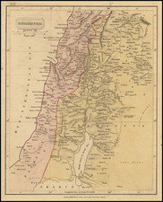
Fine example of the reduced size edition of the Conder & Kitchener Map of Western Palestine.
The orignal map created by Conder & Kitdhener consists of 26 sheets and is ordinarily found bound in atlas format.
Field Marshal Horatio Herbert Kitchener, 1st Earl Kitchener, was an Irish-born British Field Marshal and proconsul who won fame for his imperial campaigns and later played a central role in the early part of the First World War, although he died halfway through it. In 1874, at age 24, Kitchener was assigned by the Palestine Exploration Fund to a mapping-survey of the Holy Land, replacing Charles Tyrwhitt-Drake, who had died of malaria. Kitchener, then an officer in the Royal Engineers, joined fellow Royal Engineer Claude R. Conder, and between 1874 and 1877 they surveyed what is today Israel, the West Bank, and Gaza, returning to England only briefly in 1875 after an attack by locals in the Galilee, at Safed.
Conder and Kitchener's expedition became known as the Survey of Western Palestine because it was largely confined to the area west of the Jordan River. The survey collected data on the topography and toponomy of the area, as well as local flora and fauna. The results of the survey were published in an eight-volume series, with Kitchener's contribution in the first three volumes (Conder and Kitchener 1881-1885).
![[ Palestine ] Beschreibung des Heiligen Landes](https://storage.googleapis.com/raremaps/img/small/96981.jpg)
![Suite de la Genealogie ou Chronologie des Rois Patriarches et Prophetes du troisieme Periode du Monde. [Cyprus]](https://storage.googleapis.com/raremaps/img/small/91749.jpg)