|
||

|

|
|

|
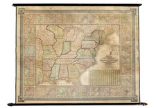
Rare separately issued War of 1812 map of the United States.
Shelton & Kensett were among America's foremost engravers of the early 19th Century and their work is highly prized among collectors.
One of the very few separately issued printed maps of the War of 1812. This is apparently 1 of 3 editions of the map, with 10 vignettes illustrating the naval battles of the War of 1812, 3 more than what would appear to be the first edition of the map and 1 more vignette than a second edition. We have some uncertainty with respect to the editions of the map. While at first appearance, it would make sense that the vignettes were added with each new edition, we note that the editions with 7 and 10 vignettes appear very similar in all other respects, whereas the edition with 9 vigettes has different spellings of Cape Fear in the vignette above the title eagle and that there are many other subtle differences throughout he map, leading us to believe that the 9 vignette edition of the map is in fact an entirely different plate, likely issued at a later date. The 9 vignette edition (copyrighted on November 8th, 1813), whereas the 7 and 10 vignette editions are dated July 6th, 1813.
The 9 Vignette map can be seen here: /gallery/detail/23798
The 7 vignette edition can be seen here: www.davidrumsey.com/luna/servlet/detail/RUMSEY~8~1~222569~5505625:An-Improved-Map-of-the-United-State
Information on the Post roads, other routes, population of states and territories is given in the borders. A curious note regarding fishing and grapes appears in northern Illinois, which seems to be unique to this map. The borders contain tables of distance on the Great Post Road from Pasamaquoddy (ME) to St. Mary's (GA), on the Post Road from Albany (NY) to Montreal ; also population and products of states.
The map includes a number of features which rarely appear on printed maps, most notably the naming of Orleans Territory as a subdivision of Lousisana. This is the only printed map we have ever seen which refers to and delineates an American Territory by this name. The map also includes a number of other fascinating early annotations and a fine representation of the post roads and other routes throughout the US. Interesting annotation regarding the fishing and grapes in Northern Illinois. Curious delineation of the Northwestern States and Territories, with Illinois pushed off Lake Michigan. Excellent early Indian details and a a fine treatment of Spanish Florida.
Orleans Territory was created on October 1, 1804 by the Organic Act of March 26, 1804 and became the first subdivision of Louisiana Territory following the Louisiana Purchase. The Territory consisted of all of the Louisiana Purchase south of the 33rd parallel, with the region to the North called the District of Louisiana. The District of Louisiana was later renamed Louisiana Territory. The Orleans Territory ultimately became the State of Louisiana on March 12, 1812, at which time Louisiana Territory was renamed the Missouri Territory.) On April 10, 1805, the Territorial Legislature organized 12 counties (Orleans County, LaFourche County, German Coast, Acadia County, Iberville County, Attakapas County, Pointe Coupée County, Opelousas County, Rapides County, Concordia County, Natchitoches County and Ouachita County). The Florida Parishes on the east bank of the Mississippi were not included in Orleans Territory at this time, as they still part of the Spanish territory of West Florida until the region was annexed in 1810. The western boundary with Spanish Texas was not fully defined until the Adams-Onís Treaty in 1819. A strip of land known as the Sabine Free State just east of the Sabine River served as a neutral ground buffer area from about 1807 until 1819.
A later reissue of this map was put out in 1825 by Lewis Robinson (see Ristow 271). The map was engraved by A. Doolittle of New Haven and Kensett of Cheshire.
![[ Promoting Emigration To The Czech Market ] Ceske Osady V Americe [ A Correct Map of the United States of America Showing Atchison, Topeka and Santa Fe R.R. and Connections ]](https://storage.googleapis.com/raremaps/img/small/101348.jpg)