|
||

|

|
|

|
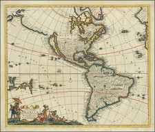
Rare separately issued map of America, published by De Wit.
The map is an amalgam of sources. The figures derive from Van den Keere's map of 1614, but with fewer town illustrations. The California model is after Luke Foxe, but the contiguous coast of the mainland from Foxe's map is inadvertently engraved as a river.
Hudson's Bay & the Great Lakes are derived from Blaeu. New Amsterdam is shown, but no evidence of English settlements. The map is based upon Dutch sources, despite the availability of more contemporary French material. Two Virginian Indians are among the illustrations.
The present example is the third state of the map, which was not initially identified by Burden but which is first referenced by Schilder.
De Wit (1629 ca.-1706) was a mapmaker and mapseller who was born in Gouda but who worked and died in Amsterdam. He moved to the city in 1648, where he opened a printing operation under the name of The Three Crabs; later, he changed the name of his shop to The White Chart. From the 1660s onward, he published atlases with a variety of maps; he is best known for these atlases and his Dutch town maps. After Frederik’s death in 1706, his wife Maria ran the shop for four years before selling it. Their son, Franciscus, was a stockfish merchant and had no interest in the map shop. At the auction to liquidate the de Wit stock, most of the plates went to Pieter Mortier, whose firm eventually became Covens & Mortier, one of the biggest cartography houses of the eighteenth century.
![America noviter delineata Auct. Judoco Hondio [Extremely rare 3 panel carte a figures state]](https://storage.googleapis.com/raremaps/img/small/66116.jpg)