|
||

|

|
|

|
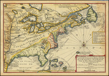
Rare French copy of Thomas Jefferys map of 1755, which originally set forth the English claims in North America, which were then contested by the French.
The map is substantially copied from Jefferys North America from the French of Mr. d'Anville, Improved with the Back Settlements of Virginia and Course of Ohio, Illustrated with Geographical and Historical Remarks, a map which continued the controversy between the French and English over the lands west of the Alleghany Mountains an in the Ohio River Valley. When Jeffery's map was published in 1755, the French had defeated the British army near Fort Duquesne. Jefferys had taken the work of the French cartographer d'Anville and made changes to show the British claims, identifying French settlements as as encroachments on English territory.
In response, this map notes the English claims to the area illustrated in Jefferys map and notes that these claims are disputed by the French (see below).
The cartouche continues: Traduit de l'Angloise d'apres Thos Gefferys Geographe du Prince de Galle, et divisee Suivant les pretendues pretntions des Anglois, sans neantmoins Entendre, qui ce la tire a Consequence en 1757.
A link to the Brish Library copy of the Jefferys map can be found here: maps.bpl.org/id/14140
The text around the map provides a detailed history of the British Colonies and is taken from Jefferys map.
![Vereinigte Staaten Von Nordamerika [United States of North America]](https://storage.googleapis.com/raremaps/img/small/92015.jpg)
![Nord-Amerika [North America]](https://storage.googleapis.com/raremaps/img/small/91328.jpg)