|
||

|

|
|

|
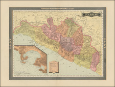
Striking Chart of the Caribbean
Scarce, fine chart of the Caribbean, Florida, the Gulf Coast, and the Southeastern part of North America, with an inset of the north coast of Cuba.
The chart stretches north to Chesapeake Bay and southeast to the Guyana coast in South America. The great sand banks near the Bahamas are especially evident. The intense shipping traffic of the area is suggested by the rhumb lines that criss-cross the region. The inset in the lower left shows the channel between Cuba and the nearby islands, another busy thoroughfare, and one frequented by pirates.
This chart appeared in Goos’ De Zee Atlas ofte Water-Weereld, first published in 1666. Goos based this general chart on the manuscript chart of Hessel Gerritsz, ca. 1631. It follows Gerrtisz especially closely in including the inset of the northwest coast of Cuba. The chart also integrates the work of Van Loon (1661) in the Gulf of Mexico and of Doncker (1659) in its orientation of the southeast coastline. However, Goos has improved the scale and depiction of the Outer Banks, even if the Yucatan Peninsula and the breadth of the eastern seaboard of North America are slightly distorted to modern eyes.
The Caribbean at this time was a hotly contested arena amongst European empires. Jamaica had fallen into English hands in the decade prior to this chart’s creation; they also controlled the area around Chesapeake Bay and farther north at this time. The Spanish had colonies in Florida, New Spain (Mexico), Cuba, and along most of the north coast of South America (today’s Venezuela and Colombia). Curacao passed from Spanish to Dutch hands in 1634, while they were gaining power in Suriname when this chart was published.
An island of especial interest is Espanola, as it is written here, or Hispaniola. This was where Columbus initially landed. It had initially been taken under Spanish control, at the expense of the Taino people, until other European powers began to encroach via piracy. The most powerful of these were the French, who established a colony on Tortuga in 1659. There were also French settlers on Grand Terre (the larger island of Santo Domingo, or Hispaniola) and the Spanish had to content themselves with splitting the island with the French by the end of the seventeenth century. Over the course of the eighteenth century, Saint Domingue became the wealthiest of the Caribbean plantation colonies, fueled by African slave labor, until revolution broke out in 1791.
Another area of interest is the coast of Central America. While European empires nominally claimed American spaces, their control was always contested by Indigenous, free, and enslaved peoples. One place that was particularly resistant to European power was the Moskito Coast. The name Moskito refers to the Tawahara Miskitu people, an Amerindian group who live along the coast. When the Spanish expanded their influence in Central America in the sixteenth and seventeenth centuries they were unable to conquer the coast, despite numerous attempts. Instead, the area became a pirate haven predicated on harassing Spanish trade; the buccaneers, particularly the English, traded with the local indigenous peoples.
Pieter Goos (ca. 1616-1675) was a Dutch map and chart maker, whose father, Abraham Goos (approx. 1590-1643), had already published numerous globes, land and sea maps together with Jodocus Hondius and Johannes Janssonius in Antwerp. Pieter gained recognition due to the publication of sea charts. He bought the copperplates of the famous guide book for sailors, De Lichtende Columne ofte Zeespiegel (Amsterdam 1644, 1649, 1650), from Anthonie Jacobsz. Goos published his own editions of this work in various languages, while adding his own maps. In 1666, he published his De Zee-Atlas ofte Water-Wereld, which is considered one of the best sea atlases of its time. Goos' sea charts came to dominate the Dutch market until the 1670s, when the Van Keulen family came to prominence.
![(California and Mexico) [Album of 68 original photographs (including 42 panoramic views): a train wreck in California; San Francisco earthquake damage; Torreon; Aguascalientes; Mexico City and more]](https://storage.googleapis.com/raremaps/img/small/98220.jpg)