


|
||

|

|
|

|
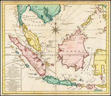
Important early map of Southeast Asia, showing the region between Ceylon, Japan, the Mariana Islands and Timor, the Philippine Islands at center, published by Thevenot in his Relations de divers Voyages.
At top left 2 small inset-maps, one showing the delta of the Ganges river; furthermore a drawing of the Great Wall in China, and a note reflecting the voyage of J. da Gama from China to Mexico. As noted by Suarez, the map is
an engraved rendering of a Portuguese portolan chart in 1664, which was the very year that the French East India Company was formed. The map appeared in the second part Thevenot's great compendium of voyages, Relations de divers Voyages, a work which was to France what Hakluyt's writing had been to England and Ramusio's had been to Italy.
The map is based upon a 1649 portolan chart by the Portugese Royal mapmaker Joao Teixeira. The present example is from the 1672 or 1696, with extensive additions of rivers, lakes, mountains, including the names of provinces to the interior of China. This edition also includes newly engraved compass lines
J. N. Delisle believed that the original chart came into Thevenot's possession after a French ship had pirated it from a Portuguese carrack. Parts of the portolan original are attributed to a Portuguese merchant in Macao by the name Don Joao da Gama . . . Most of the chart, however, probably reflects the Portuguese padroao of the time."
![[Clans Assigned to Defence Duty on Land and Sea in lzu, Sagami, Musashi, Kazusa, Shimofusa, and Boshu] (same as Awa) [Provinces for Maintaining Peace] [lzu, Sagami, Musashi, Kazusa, Shimofusa, Boshu Kairiku okatame taihei kagami]](https://storage.googleapis.com/raremaps/img/small/55560.jpg)