This item has been sold, but you can enter your email address to be notified if another example becomes available.


|
||

|

|
|

|
Stock# 30597
Description
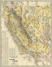
Scarce map of Colorado, showing the relative rainfall throughout the state, published by the Colorado State Board of Immigration.
The map is color coded for rainfall, and also whows county seats, county lines, railroads, trunk line railroads, electric railroads, national forests, national parks, and various automobile roads.
A fine example of this scarce early map. Copyrighted 1917. Several later editions were published.