The item illustrated and described below is sold, but we
have another example in stock. To view the example which
is currently being offered for sale, click the
"View Details" button below.


|
||

|

|
|

|
Stock# 30547
Description
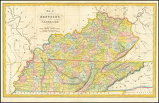
Scarce early map of Kentucky & Tennessee, showing counties, towns, roads, rivers, lakes, mountains, court houses, Indian Villages, Forts, etc.
County configurations are not yet complete.
One of the earliest separate maps of the states published outside of America. Gorgeous full color example.

![Carte De La Louisiane Et Du Cours Du Mississipi . . . Juin 1718 [1st State!]](https://storage.googleapis.com/raremaps/img/small/59797.jpg)

![[Rare First State] Novissima Tabula Regionis Ludovicianae Gallice dictae la Louisiane . . .](https://storage.googleapis.com/raremaps/img/small/72622.jpg)