This item has been sold, but you can enter your email address to be notified if another example becomes available.


|
||

|

|
|

|
Stock# 30491
Description
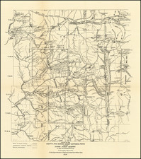
Detailed 4 sheet map of Santa Monica Bay, illustrating a report considering the feasibility of locating a deep water harbor in Santa Monica Bay, conducted by the Army Corps of Engineers in 1890.
The full title of the map is: C hart of Santa Monica Bay California. To Accompany Report of Board of Engineer Officers on Location of a Deep Water Port Between Port Dume and Point San Juan Capistrano . . . 1890
Condition Description
4 sheet map w/report. Minor toning at folds.

![[ San Francisco Bay and Approaches ] Chart of the Farallones and Entrance to the Bay of San Francisco... 1850](https://storage.googleapis.com/raremaps/img/small/98405.jpg)
![[Geology Map of the Texas, California & the Southwest] Esquisse Geologique Des Anciennes Possessions Mexicains Du Nord Incorporees Ala Federation des Etats-Unis . . . 1867](https://storage.googleapis.com/raremaps/img/small/71446.jpg)