|
||

|

|
|

|
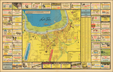
Nice example of John Mullan's Guide Book and Map, one of the most influential works of its time.
Wheat devotes several pages of description to the map, which is a remarkable snapshot of the period and full of interesting details, not the least of which are the fine topographical renderings of Edward Freyhold and the plotting of trails west, including the variants of the Mullan road from Fort.
Mullan's guide book is a valuable original source on the early gold discoveries in western states. Mullan, the former superintendent of construction on the northern overland wagon road, provides advice for the traveler in a day-by-day itinerary of his route from Fort Benton, Montana, through the mountains to Walla Walla in Washington territory. Sections of the book cover "Recommendations for Travellers," "Advice to Emigrants by this Route," "Indians along the Route," and a number of other topics. Added is an extended discussion by Mullan on "The Geography, Topography and Resources of the North-Western Territories," and Streeter notes that "one of the best features of the
Guide is its 'Addenda' . . . which is devoted primarily to the then recent developments in gold and silver mining in Idaho." He adds that "the large folding map is helpful and important."
In fact, Wheat calls the map "very fine" and reproduces it as the frontispiece of volume 5 of
Mapping the Transmississippi West. Handsome and impressive, the map shows Dakota; Nebraska; Montana; Idaho; Washington; Oregon; the northern portions of California, Nevada, Utah, and Colorado; and what Wheat calls the "new idea" of Wyoming: "The most curious, if not the most important, cartographic event of [1865] is the appearance on Western maps of the idea of Wyoming." That territory had just been created in January 1865, only eight months after the birth of Montana, making the present map very up-to-date as regards its showing of political boundaries.
As noted by Rumsey:
Strange Owyhee depiction - shows Kearney River and the Jordan Creek flowing into the Owyhee and a road from "Star City" on the Humboldt (which is actually in Buena Vista Valley south of the Humboldt!) going north through the Owyhee to Boise. Map is very incorrect regarding northern Nevada and Southeastern Oregon. Kearney River comes from the Dixon map of 1860, but Dixon puts the Kearney where Freyhold puts the Jordan. Much detail on the Owyhee Mines in the addenda.
Full Title of the Book: Miners and Travelers' Guide to Oregon, Washington, Idaho, Montana, Wyoming, and Colorado. Via the Missouri and Columbia Rivers. Accompanied by a General Map of the Mineral Region of the Northern Sections of the Rocky Mountains. 8vo. 153pp.