This item has been sold, but you can enter your email address to be notified if another example becomes available.


|
||

|

|
|

|
Stock# 30411
Description
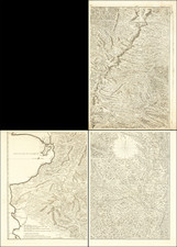
Interesting manuscript map of part of the central highlands of Peru, from Jauja in the north to Huancayo and Chupaca in the south.
The map covers a little more than 50 miles north-to-south and east-to-west.
Many smaller villages and hamlets are noted, with an internal symbolic system of small triangles, circles, and crosses to denote size and other aspects of the communities - unfortunately, there is no key to decode these symbols.
Topography is rendered with hachuring.
Dating is based on orthography.
An intriguing map worthy of further study.
![[Peruvian and Bolivian Coast] Sheet XI Bolivia and Peru Cape Paquica To Cape Lobos By Captn. Robert Fitz Roy R.N. The Officers of H.M.S. Beagle 1836](https://storage.googleapis.com/raremaps/img/small/73464rd.jpg)
![[Ecuador & Peru Coastlines] Carta particolare del'Peru che comincia con il capo di Guanapo e finisce con il C. S: Francesco . . .](https://storage.googleapis.com/raremaps/img/small/40798.jpg)