
This item has been sold, but you can enter your email address to be notified if another example becomes available.


|
||

|

|
|

|
Stock# 30382
Description
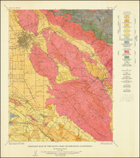
Detailed early map of the San Fernando Valley, published for California Bank.
The map locates the early Electric and Steam railroad lines, towns, post offices and roads in San Fernando Valley, at the beginning of its first major real estate boom. Several proposed street car lines are also shown, along with the Proposed Mullholland Skyline Drive.
Some of the early towns listed have long since been absorbed by other towns, including Girard, Owensmout, Zelzah, Wardlaw, Wahoo, Raymer, Hewitt, and Roscoe.
Condition Description
Minor loss of image at several folds.
![[ California Petroleum ] A Description of the Recently Discovered Petroleum Region in California. With A Report on the Same. (with) Map Representing Locality of The Ojai Ranch in Santa Barbara County, California, belonging to the California Petroleum Company 1865](https://storage.googleapis.com/raremaps/img/small/103844.jpg)
![[ Baja California / Gulf of California ] Carta Esferica de las Costas y Golfo De Californias Llamado Mar De Cortes Que Comprende desde el Cabo Corrientes hasta el Puerto de San Diego Construida …. 1825](https://storage.googleapis.com/raremaps/img/small/102732.jpg)
![[Monterey] Plan De La Baie De Monterey Situee Dans La Californie Septentrionale . . .](https://storage.googleapis.com/raremaps/img/small/99008.jpg)
![California [with large inset of Utah and Part of New Mexico]](https://storage.googleapis.com/raremaps/img/small/92004.jpg)