|
||

|

|
|

|
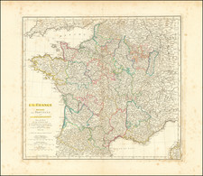
Detailed plan of the City of Paris and the immediate surrounding area, most of which is now within the City.
The map shows places like Montmarte, Clignancour, La Villette, Vincennes, La Chapelle, Clichy, Pont de Neuilly, Issy, Vaugirard and Gentily at a time when they were still small villages and not yet absorbed within the urban sprawl of Paris. St. Denise aperas at the top.
The map shows a number of early roads and bridges across the Seine and Marne Rivers. A nice look at Paris and environs as it existed at the beginning of the 18th Century.
Nicholas de Fer (1646-1720) was the son of a map seller, Antoine de Fer, and grew to be one of the most well-known mapmakers in France in the seventeenth century. He was apprenticed at twelve years old to Louis Spirinx, an engraver. When his father died in 1673, Nicholas helped his mother run the business until 1687, when he became the sole proprietor.
His earliest known work is a map of the Canal of Languedoc in 1669, while some of his earliest engravings are in the revised edition of Methode pour Apprendre Facilement la Geographie (1685). In 1697, he published his first world atlas. Perhaps his most famous map is his wall map of America, published in 1698, with its celebrated beaver scene (engraved by Hendrick van Loon, designed by Nicolas Guerard). After his death in 1720, the business passed to his sons-in-law, Guillaume Danet and Jacques-Francois Benard.
![(Anti-Nuclear Energy Poster) Le Nucleaire Creera des Emplois [Nuclear Will Create Jobs]](https://storage.googleapis.com/raremaps/img/small/82811.jpg)