


|
||

|

|
|

|
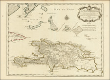
Fine detailed plan of the island of Santa Domingo, first published by Guillaume De L'Isle.
Excellent detail throughout includes realistic depictions of bays, mountains, islets, lagoons, forests, etc., which are combined with details of human development of the flourishing colony. Each town, plantation house, windmill, watermill, and sugar works is indicated, as well as gun emplacements, fortifications, anchorages, and government houses.
Philippe Buache (1700-1773) was one of the most famous French geographers of the eighteenth century. Buache was married to the daughter of the eminent Guillaume Delisle and worked with his father-in-law, carrying on the business after Guillaume died. Buache gained the title geographe du roi in 1729 and was elected to the Academie des Sciences in the same year. Buache was a pioneering theoretical geographer, especially as regards contour lines and watersheds. He is best known for his works such as Considérations géographiques et physiques sur les découvertes nouvelles dans la grande mer (Paris, 1754).
![[Saint-Marc, Haiti] Plan de la Ville de St. Marc, dans l'Isle St. Domingue . . . 1785](https://storage.googleapis.com/raremaps/img/small/88259.jpg)