


|
||

|

|
|

|
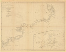
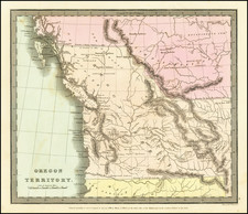
Striking example of the Jeramiah Greenleaf's map of Oregon Territory, which appeared in his Universal Atlas.
Rich with Indian information and details of the earliest settlments in Oregon Territory. This fascinating map was the only commercial atlas map to depict Oregon Territory on a separate map. Extending to 54 degrees 40 minutes, it reflects the then active dispute between the US and British interests over the region which would become the southern part of British Columbia, which were not resolved until a decade later. The discoveries of Lewis & Clark, the Hudson's Bay Company and John Jacob Astor's Company are in evidence, along with some of the fascinating early water routes from the Pacific to Salt Lake (Timpanagos) and other mythical pre-Fremont Cartography.
An essential Northwest Map.