|
||

|

|
|

|
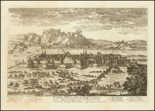
Detailed plan of the Battle of Neerwinde, showing the battle fought between the French & English armies on the north side of the Gette River, between Leuven and Helcine, during the 9 Years War.
The Battle of Neerwinden (or Landen), in the current Belgian province of Flemish Brabant, was a battle in the Nine Years' War, fought on July 29, 1693, between the French army of Marshal Luxembourg and the Allied army of King William III of England. The French assaulted the Allied position three times before the French cavalry finally penetrated the allied defences and drove William's army from the field in a rout.
The battle was quite costly for both sides. The French losing 9,000 men to the Allies' 19,000, the French failed to follow up on their victory, allowing William to escape.
The plan provides a highly detailed look at the troop positions of the combatants and is quite rare. We were not able to locate another example at auction or in a dealer catalogue.
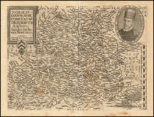
Pierre Duval (1618-1683) was a French geographer, cartographer, and publisher who worked in Abbeville and Paris during the seventeenth century. He was born in the former city, in northeast France, before moving to Paris. Duval was the nephew of the famous cartographer Nicolas Sanson, from whom he learned the mapmaker's art and skills. Both men worked at the royal court, having followed the royal request for artists to relocate to Paris. In addition to numerous maps and atlases, Du Val's opus also includes geography texts. He held the title of geographe ordinaire du roi from 1650 and died in 1683, when his wife and daughters took over his business.
![(Second World War - The Aftermath - Abdication of Leopold III) En Pleine Guerre! Voici le Domaine dont Leopold III Revendiquait les Titres: Saxe-Cobourg-Gotha. . . [In the middle of a war! Here is the region where Leopold III Claimed Title: Saxony, Coburg, Gotha. . .]](https://storage.googleapis.com/raremaps/img/small/91010.jpg)