|
||

|

|
|

|
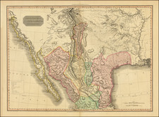
Detailed map of the route from Santa Fe, New Mexico to the Gilla River, via Tucson, as undertaken by Lt. Colonel Philip St. George Cook in 1846 and 1847.
Map shows locations of Cooke's camps, distances between points, trails, alternative routes, areas of Indian activity, mining activity, and water sources. Includes notes and table of distances.
Adjunct to W.H. Emory's main map of the route of the Army of the West under Kearny across the southwest to California; Lt. Col. Phillip St. George Cooke and the "Mormon Battalion" took a more southerly route through the Guadeloupe Mountains and Tucson, producing this modest but important map. Wheat describes the map as a "magnificent achievement" drawing public attention to a stretch of territory deemed essential for a wagon and rail route that was later included in the Gadsden Purchase. The map terminates at the Pima Villages on the Gila (near present day Phoenix) where Cooke followed Kearney's trail westward into California.
From 30th Congress, 1st Session, House Doc. 41.