


|
||

|

|
|

|
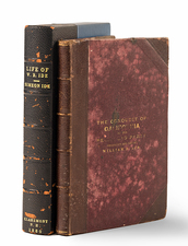
Nice example of Thomas O. Larkin's map of the Sacramento Valley, including the newly discovered gold regions, the first printed map of the gold regions.
Thomas Oliver Larkin was an early California merchant, who served as U.S. Consul to the Province of California and U.S. Consul to the Republic of California, following the Bear Flag Revolt. His 2 letters to the president in June 1848 are two of the earliest communications of the discovery of gold in California sent to the East and his map of the Sacramento Valley was the first printed map to show the Gold Regions.
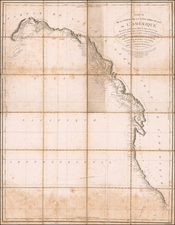
The map shows Ranchos in the Central Valley and along the American river has "Gold Region" on both sides. The original was traced from a map prepared for Bidwell in 1844.
Full Title: Map of the Valley of the Sacramento including the Gold Region. This map is a correct tracing of the map of Bidwell, Land Surveyor, by Thos. O. Larkin Esq: late Consul of the U.S. for California; and by him stated to be the best reference in California.
With Folding cloth case, 5"x 3 1/4", blind stamped, "Gold Region" in gilt on front cover; on verso of front cover, printed paper label, in gilt, reading, "A Correct Sruvey of the Gold Region California."
![[California in Miniature] Bird's-Eye View Map Showing Its Prominent Topographical Features, Location of Principal Cities, Towns and Points of Note, Also Lines of the Southern Pacific Company. 1898.](https://storage.googleapis.com/raremaps/img/small/63460.jpg)
![[Imperial Valley]](https://storage.googleapis.com/raremaps/img/small/69292.jpg)
![[Appointment of Ben E.S. Ely as Notary Public for Napa County, California - September 26, 1861]](https://storage.googleapis.com/raremaps/img/small/93309.jpg)