|
||

|

|
|

|
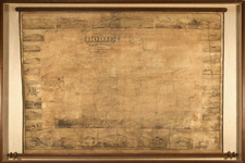
Rare subdivision map for a planned subdivision of Burbank called Benmar Hills, which was to be built around "a great university," Benmar Hills University, the proposed name for the Southern Branch of the University of California, which would become UCLA.
The present map would appear to be the only surviving example of the original promoter's map showing the full extent ofthe promoter's plans, providing a remarkably detailed town plan of Burbank, the University Site and a host of other proposed civic and commercial improvements.
Benmar Hills was the product of a land boom in Burbank, which began in the 1920s. The development extended from Walnut to the edge of Burbank and from Glenoaks up to the hills. Hollywood real estate promoter Ben W. Marks bought a part of the Stough Ranch property in 1919. He planned to develop a subdivision that would equal the Wilshire Boulevard area. He donated the present site of McCambridge Park to the city for a municipal center and hoped that the southern branch of the University of California (UCLA) would be located in the Benmar Hills residential area.
The once-favored Burbank site was rejected when the Janss Investment Company donated the land in what is now Westwood to the University and UCLA was subsequently built in Westwood. Marks' promotion began to collapse and ended in financial disaster, defaulted bonds, and confused property title claims.
The following link includes a number of early illustrations of the proposed development. wesclark.com/burbank/benmar.html

![(California-Mexico Border Survey) Datos de los trabajos astronómicos y topográficos. [bound with:] Variedades de la civilizacion, nueva epoca (Tomo I)](https://storage.googleapis.com/raremaps/img/small/70777.jpg)
![[ Southern & Central California Yokuts ] The Southern and Central Yokuts](https://storage.googleapis.com/raremaps/img/small/103201.jpg)
![[Fruit Crate Label Advertising Map] Star of California Brand](https://storage.googleapis.com/raremaps/img/small/41396.jpg)