|
||

|

|
|

|
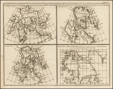
Rare separately issued map of the routes to the Klondike and Yukon mining regions, featuring the Dalton Trail and Copper River routes to the Gold Fields, likely published surreptiously by Joseph Burr Tyrrell of the Geological Survey of Canada, shortly before his resignation from the GSC.
Tyrrell's map is without question one of the finest maps of the region published at the outset of the Klondike and Yukon gold rush in 1897. The meticulous delineation of the Dalton Trail (and 2 related trails) and Cooper River routes to the region, delineation of topographical details, elevations and annotations within the map are of particular note, providing many fine details not normally included in this type of ephemeral "boom" guide map. A note in the center of the map gives details on the currents of the Yukon and Lewes Rivers, depths and notes regarding the increased depth and navigability by steamships in the Spring. A second note lengthy note describes the use of the White River as access to the region, a 5 day Portage between the Tanana River and the White River, and a number of other trail notes.
The map also illustrates a number of the coastal Glaciers in the region, including Bering Glacier, Malaspina Glacier, Grand Plateau Glacier, Muir Glacier, Mead Glacier and Miles Glacier. The fine details reflect the best available information (to which Tyrrell would have had excellent access) and depicts in remarkable detail the major (and minor) routes to the mining regions. A large inset map of the Klondike River and Affluents shows Dawson and the area to the south, with a Table of Distances below.
The central theme of the map, illustrating the Dalton Trail and Copper River routes, both ending on the Yukon River, along with the unnamed proposed overland route from Yakult Bay to the White River and on to the Upper Ramparts, includes a number of interesting notes along each route. The Dalton Trail is actually shown branching into two trails north of the Hootch-I (Hutchi) Village and "G. Bound's Trail" is also shown running more or less parallel to the Dalton Trail, beginning north of Chilkut.
One of the more noteworthy features of the map is Tyrrell's lack of knowledge of the topography along the northern half of the Dalton Trail. Beginning north of the Hooch-I (Hutchi) Village, the eastern of the two "Dalton Trail" forks heads generally toward Nordenskold River, depicting the true Dalton Trail route, which met up with the river at a point where it became navigable, before flowing toward the Yukon River via the Lewes River. The western of the two forks, headed toward I-Shi-Ih (Aishihik) Lake, was often mistakenly described on contemporary maps as the Dalton Trail. This trail was in fact the scene of a cattle drive led by Dalton in 1897, which crossed the Nissling River and on to Fort Selkirk, a route which appearently allowed the 60 cattle, 40 oxen and 2 milk cows which made the trip to fatten up before reaching Ft. Selkirk. Inspector Jarvis of the North West Mounted Police reported in 1898 that Dalton never attempted the route again, as it took him over a 5500 foot mountain range, stating that the "trail was something awful." Clearly, even Tyrrell, with the best available official survey information, was forced in 1897 to speculate as to the terrain encountered on the two routes and the G. Bound Trail to the east (see below).
Tyrell's map is recorded in two copies, one at Yale and the other at the University of Utah (which curiously shows much larger dimensions). No examples have appeared at auction and only a single example is recorded in a dealer catalog (Eberstadt Catalog 134, #16, 1945).
The Dalton Trail runs between Pyramid Harbor, west of Haines, Alaska and Fort Selkirk, in the Yukon Territory of Canada, using the Chilkat Pass. Originally, the Chilkat group of Tlingit controlled the trail, which they used for trade with the Athabascans. With the arrival of Europeans, the Chilkat acted as middlemen between the traders and Athabascans. The Chilkat trade monopoly was broken in 1890 when E. J. Glave, John (Jack) Dalton and several others were hired by Leslie's Illustrated Magazine to explore the interior of Alaska. While exploring the Grease Trail, they saw the possibility of a trade route. Dalton and Glave returned in the spring of 1891. After Glave's death, Dalton remained in the area, developin a series of trading posts. In 1899, he began charging a toll to use the Grease Trail, which by then was known as the Dalton Trail. During the Klondike Gold Rush many prospectors walked the trail to Ft. Selkirk, where log rafts would float men, horses and cattle to Dawson City.
The G. Bound Trail or G. Bound Overland Route appears on a number of maps and is referenced in at least one contemporary book, Jerome Dyer's The Routes and Mineral Resources of North Western Canada (1898), The route is named for George Bounds, a member of Willis Thorp's party which drove a herd of 40 cattle from Haines, Alaska to the Yukon River in 1896. Just north of the Tlingit village of Klukwan, the party encountered Jack Dalton, who threatened the party if they used "his trail." Thorp's party veared slightly to the east, then up the Chilkat Valley and over the mountains to Lake Arkell (Kusawa Lake) and on to the Lewes River and the Yukon River. G. Bound's Trail was probably only used once, as Dalton's Trail was the more practical route and starting in 1897 became the primary route for cattle, sheep and horses bound for the Klondike and Yukon regions.
While the map shows a copyright to "John B. Tyrrell," the maker of the map is almost certainly Joseph Burr Tyrrell (1858 - 1957), a Canadian geologist, mapmaker and mining consultant, who was just then making the transition from the Geological Survey of Canada to the gold mining industry. It seems most likely that Tyrrell elected to publish the map under an assumed name (John B. Tyrrell) or that the map's publisher simply got the name wrong (although we have not been able to explain the connection with Oakland, California, shown in the map credit). Even more curious is the notation that the map was "Compiled From Latest U.S. Surveys and British Authorities And Other Sources," with no reference to the Canadian Geological Survey.
It is known the Tyrrell was the source of the information for a Map of Central Alaska, Cook Inlet and Copper River, including Klondike, White, Tanana and Munook Rivers, published in Washington in 1897 by the United States Coast Survey. He also published a Map of the Klondike Gold Field and vicinity. ... By J.B. Tyrrell in Dawson City in 1899 (one known example -- British Library). The Royal Geographical Society's Geographical Journal for 1899 (volume 13, page 692) lists Tyrrell as a Mining Engineer in Dawson City and notes:
Presented by the Author. This map includes the results of the latest official surveys, and will doubtless be useful to those having an interest in the Klondike Gold Fields. It is apparently reduced by photography from a larger map, with the not unusual result that some of the names are too small to be read with ease.
Another of Joseph Burr Tyrrell's contemporary publications was List of plants collected by Mr. J. B. Tyrrell in the Klondike region in 1899, (Ottawa Naturalist for December, 1899, vol. xiii, no. 9, p. 209-218.). Tyrrell published a number of works on Gold Mining, including The Gold of the Klondike, in 1912. Tyrrell also took many photographs of the communities and mining operations in the goldfields. The Tyrrell collection is held by the Thomas Fisher Rare Book Library in Toronto. It includes Klondike photo albums, prints, glass plate and cellulose negatives, and glass lantern slides dating from 1898 to 1905. He also acquired the biographical recollections of David Thompson and published them as David Thompson's Narrative . . . in 1916.
Based upon these extensive contacts with the region, it is difficult to imagine that John B. Tyrrell was someone other than Joseph Burr Tyrrell.
Originally trained as a lawyer, Tyrrell joined the Geological Survey of Canada in 1881 and led a number of expeditions to Western Canada over the next 15 years. This map of the Klondike Region marks Tyrrell's transition into the gold-mining industry, a career which he would pursue for the next 50 years.
Tyrrell had gone to the Klondike area in 1898. There he recognized the potential for making money which far exceeded his Geological Survey wages. He resigned from the Geological Survey and went back to the Yukon. Once back in Dawson, Tyrrell opened a mining consulting business, despite having no formal training. The business proved quite successful in investigating possible claims. Tyrrell moved his firm to Toronto in 1907 to be closer to his family and take advantage of the cobalt and silver rush taking place in northern Ontario. In 1924, he invested in the Kirkland Lake gold mine in eastern Ontario, finally realizing his fortune.
His contributions to the history of Canada are well doumented. The Royal Society of Canada awards the J.B. Tyrrell Historical Medal in recognition of Tyrrell's outstanding work in the history of Canada.
The history of the mining boom in the Klondike and Yukon regions begins in 1896. In August 1896, three people led by Keish (Skookum Jim Mason), a member of the Tagish First Nations, headed north, down the Yukon River from the Carcross area, looking for Keish's sister Kate and her husband George Carmack. The party included Skookum Jim Mason, his cousin, known as Dawson Charlie (or sometimes Tagish Charlie), and his nephew Patsy Henderson. After locating George and Kate fishing for salmon at the mouth of the Klondike River, they ran into Nova Scotian Robert Henderson who had been mining gold on the Indian River, just south of the big dike. Henderson told George Carmack about where he was mining and that he did not want any "Siwashes" (meaning Indians) near him.
On August 16, 1896, the Skookum party discovered rich placer gold deposits in Bonanza (Rabbit) Creek, Yukon. The news spread to other mining camps in the Yukon River valley. Gold was first discovered in Rabbit Creek, which was later named Bonanza Creek. The Bonanza, Eldorado, and Hunker Creeks were rapidly staked by miners who had been previously working creeks and sandbars on the Fortymile and Stewart Rivers.
News reached the United States in July 1897, at the height of a significant series of financial recessions and bank failures in the 1890s. The first prospectors arrived in San Francisco, California on July 15 and in Seattle, Washington on July 17, setting off the Klondike stampede. In 1898, the population in the Klondike may have reached 40,000, which threatened to cause a famine.
The boom brought many interesting people, including William Howard Taft (Camp Skagway #1), who went on to become a U.S. President; Frederick Russell Burnham, the celebrated American scout who arrived from Africa only to be called back to take part in the Second Boer War; and W. W. White, author and explorer.
Most prospectors landed at the Alaskan towns of Skagway and Dyea, both located at the head of the Lynn Canal. From these towns they traveled the Chilkoot Trail and crossed the Chilkoot Pass, or they hiked up to the White Pass and then to Lake Lindeman or Bennett Lake, the headwaters of the Yukon River. Here, the prospectors built rafts and boats that would take them the final 500-plus miles down the Yukon to Dawson City, near the gold fields.
The miners had to carry a year's supply of goods over the passes to be allowed to enter Canada. At the top of the passes, the miner's met Canada's North West Mounted Police at a post that enforced the provisions regulation, as well as customs and duties. It was put in place to avert shortages like those that had occurred in the previous two winters in Dawson City, and also to restrict the entry of guns, particularly handguns, into British territory. Another reason was to keep out of Canadian territory the criminal element which had established itself in Skagway and the other Yukon Ports (then still claimed as British territory), as well as the fears by British and Canadian authorities about a possible armed takeover of the goldfields as an American territory.
Once the bulk of the prospectors arrived at Dawson City, most of the major mining claims of the region were already established. However, any major potential unrest with the idle population was averted with the firm authority of the North West Mounted Police, under the command of Sam Steele.
Tyrrell's map is without question one of the finest privately printed maps of the period, capturing in fine detail the geographical information of the period, yet retaining the crude folk art quality which is characteristic of most maps created at the beginning of the Alaskan Gold Rush. See, for example, the Nome Mining Company map illustrated here: /gallery/detail/19071
Joseph Burr Tyrrell (1858 – 1957) was a Canadian geologist, cartographer, and mining consultant.
He is perhaps best known for his discovery of dinosaur (Albertosaurus) bones in Alberta's Badlands and coal around Drumheller in 1884.
Tyrrell graduated from Upper Canada College in 1876 and received a law degree from the University of Toronto in 1880. Shortly after his admission to practice, his doctor advised him to work outdoors due to his health.
He joined the Geological Survey of Ottawa in 1881, leading or participating in numerous explorations. He led the 1893 and 1894 expeditions into the Northern Barren Lands - down the Dubawnt River - the first visit to the Kivalliq Region Barrenlands by a European since the explorations of Samuel Hearne in the 1770s. Younger brother, James W. Tyrrell accompanied Tyrrell on the expeditions, which included first European contact with the Ihalmiut, an Inuit people, now almost extinct.
In 1894, Tyrrell stumbled upon biographical recollections (11 books of field notes, 39 journals, maps and a narrative) of Canadian overland explorer, cartographer and fur trader David Thompson and, in 1916, published them as "David Thompson's Narrative".
Tyrrell went into the gold-mining business in 1898, a career that would last more than 50 years. He was mine manager of the Kirkland Lake Gold Mine in northern Ontario for many years.