


|
||

|

|
|

|
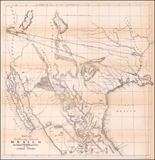
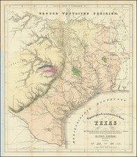
First edition of Bradford's map of the Republic of Texas, the first printed map of the Republic.
The present example is in full wash color, the first time we have ever seen a full color example of the map.
An essential map for Texas collectors, the first edition of the first reasonably obtainable separate map of the Republic of Texas.
Thomas Gamaliel Bradford (1802-1887) was an American geographic publisher. He hailed from Bradford, Massachusetts and began his publishing career by working for the America Encyclopedia. Then, he edited and republished the Atlas Designed to Illustrate the Abridgement of Universal Geography, Modern & Ancient, which had originally been offered in French by Adrian Balbi. In 1835, he published another atlas, A Comprehensive Atlas: Geographical, Historical & Commercial, and, in 1838, An Illustrated Atlas Geographical, Statistical and Historical of the United States and Adjacent Countries. His interests were primarily in educational publishing and he was one of the first mapmakers to show Texas as an independent country.
![Nouvelle Carte Du Mexique, Du Texas Et D'Une Partie Des Etats Limitrophes . . . 1840 [Proposed Railroads In Texas -- First Appearance of Arizona on a Printed Map]](https://storage.googleapis.com/raremaps/img/small/103480.jpg)
![[ Texas - Dallas to El Paso ] Flight Chart- Dallas Fort Worth to El Paso, U.S.A.](https://storage.googleapis.com/raremaps/img/small/98371.jpg)