


|
||

|

|
|

|
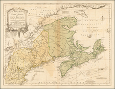
Rare early map of eastern North America west to the Mississippi River, and one of the earliest obtainable English maps to focus on the whole of the region.
This map of the eastern part of North America features a prominent, entirely fictitious, mountain range extending from Michigan into Florida, connecting with the Appalachians along the way. The map is based on numerous Jesuit and French sources of information on the Great Lakes and Canada. The error was perpetuated on maps into the nineteenth century.
The English colonies are shown drawn on recent cartography such as the Hermann map of Virginia and Reed map of William Reed's manuscript map of New England, and the recent grants of Pennsylvania and west New Jersey.
The map includes a wonderful treatment of the Great Lakes, a fascinating transcontinental mountain range from Michigan to Florida, wonderful depiction of the Mississippi River and terrific detail of the British Colonies. Morden's map was an early example of English maps that were prepared to attack French claims to the lands in the interior parts of North America. Compiled during the War of the League of Augsburg, or King William's War (1689-97), Morden's original map showed the English extending westward, into the regions traditionally claimed by the French. In addition to the Midwest, much of Canada is shown as English. The English colonies along the Atlantic Seaboard are carefully delineated according to English sources; however, Canada, the Mississippi Valley, and the Great Lakes are based on French sources, including the maps of Dablon (1672) and Thevenot (1681).
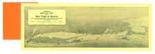
An inset map of Boston Harbor appears next to the title cartouche, based on Thomas Pound's A New Mapp of New England from Cape Codd to Cape Sables (1691).
Robert Morden (d. 1703) was a British map and globe maker. Little is known about his early life, although he was most likely apprenticed to Joseph Moxon. By 1671, Morden was working from the sign of the Atlas on Cornhill, the same address out of which Moxon had previously worked. Most famous for his English county maps, his geography texts, and his wall maps, Morden entered into many partnerships during his career, usually to finance larger publishing projects.
![Partie De L'Amerique Septent? Qui comprend La Nouvelle France ou Le Canada . . . [Large Great Lakes Inset]](https://storage.googleapis.com/raremaps/img/small/48752.jpg)

![[ Carolinas & Georgia ] Virginiae Partis australis, et Floridae partis orientalis, interjacentiumqus regionum Nova Descriptio](https://storage.googleapis.com/raremaps/img/small/81554.jpg)