The item illustrated and described below is sold, but we
have another example in stock. To view the example which
is currently being offered for sale, click the
"View Details" button below.
1832 Hinton, Simpkin & Marshall
$ 295.00


|
||

|

|
|

|
Stock# 29916
Description
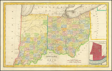
Scarce early regional map of Ohio and Indiana, with part of Micigan Territory, fro one of the earliest maps published outside the US to focus on this area.
The map is hand colored by counties and shows the primitive northern portion of Indiana, dominated by the Pottowatomies and Kickapoos lands, although Allen County and Fort Wayne are now shown, the only Northern County to appea. Michigan Territory shows only a few primitive early counties, including Washtenaw, Wayne, Lenawes and Monroe. Detroit and a few other towns are noted.
The large inset of Cincinnati is one of the earliest town plans obtainable.
![Comparative Size of Lakes and Islands [Great Lakes, Cuba, Formosa, Ireland, Sicily, Cyprus, Vancouver, Sandwich Islands, Puerto Rico, Corsica, Sardinia, Balearics, Malta, etc]](https://storage.googleapis.com/raremaps/img/small/100135.jpg)