|
||

|

|
|

|
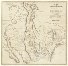
Zebulon Pike's Landmark Map of the Rocky Mountains, Texas and the Southwest--French Edition!
One of the most important regional maps of the American West, Zebulon Pike's map provides a detailed view showing the central region of what would become the Continental United States as seen on Pike’s second exploratory expedition (1806-7). This example is from the French edition of the popular account of the expeditions.
This was the first map of the American Southwest based on first-hand observations.
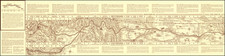
In the west the map follows the Rockies and includes, from north to south, the Platte River to the Red River. In the middle is the Arkansas River, which is especially detailed thanks to the attentions of Pike’s men as they camped along its shores. On the far side of the Rocky Mountains, four rivers are shown and labeled as the “Head Waters of California.”
In the Rockies, a large formation looms over the surrounding terrain. This is labeled “Highest Peak” and refers to what is now known as Pike’s Peak. Pike and his men attempted to climb the mountain but they did not complete their ascent.
There are many original notes, especially along the Arkansas, about the navigability of the river, local fauna, previous explorations, and the quality of the surrounding countryside.
Pike identifies the hydrographic sources of the Arkansaw [Arkansas] and Red Rivers—the main objective of his second expedition—in New Mexico. He also traces the route taken by the Spanish in pursuit of Pike’s force; they were perceived as a threat to Spanish sovereignty in New Spain.
This map was meant to serve as the western half of a larger map; the eastern half was also included in the account. This part of the map includes the reference key, which identifies:
- American camps (X)
- Spanish camps (O)
- Limits of Pike's actual surveys
- Spanish Villages and towns
- Indian Villages
Pike also identifies Lieutenant Wilkinson as the surveyor of a section of the Arkansas River, Captain Many as the surveyor of the White River, Thomas Freeman as the surveyor of the Red River, and William Dunbar as the surveyor of the Washita River.
He also mentions a Captain M. Lewis as responsible for the Missouri River, a reference to Meriweather Lewis of the Lewis and Clark expedition. The Mississippi is taken from Abraham Bradley’s map of the post roads of the United States.
The map was prepared to illustrate the first edition of An Account of Expeditions to the Sources of the Mississippi, and Through the Western Parts of Louisiana, to the Sources of the Arkansaw, Kans, La Platte, and Pierre Jaun, Rivers; ... During the Years 1805, 1806, and 1807. And a Tour Through the Interior Parts of New Spain, When Conducted Through These Provinces, by order of The Captain-General, in the year 1807, published in 1810. It proved popular and was quickly published in French, German, and Dutch editions.
The detail between the Missouri River and the Red River is truly extraordinary, and includes many original notes and observations which make this a source map for all maps which came after.