|
||

|

|
|

|
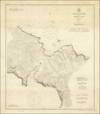
Unique separately of the northwest part of the San Fernando Valley, focusing on Porter Ranch and Chatsworth, likely prepared by the Southern Pacific Railroad Company.
The present map was acquired as part of a large archive of maps discarded by the Southern Pacific Railroad in the early 1980s. We surmise that the map was part of the Southern Pacific's expansion planning for the region, shortly after the completion of the Santa Susana Tunnel and the beginning of the residential and commercial growth in the San Fernando Valley in the early part of the 20th Century. The map is a unique artifact, traced by a Southern Pacific Engineer from a map held by the County Surveyor, then augmented with a title and manuscript additions for use by the railroad. Some of the features shown on this map are likely not on the original source map.
The map focuses on the lands owned by the B.F. Porter (Benjamin Porter) estate in the San Fernando Valley, as well a showing the lands of the Zehal Ranch, Hubbard & Wright, Porter Land & Water Company Subdivision #1, the Vera Tract, Pico Reserve, the San Fernando Misslion and the town of San Fernando. The Simi Rancho lands are shown at the northwest corner.
At the a far east side of the map,the Southern Pacific Company's Valley Line is shown, extending from the San Fernando Station to a Tunnel. The Southern Pacific's Coast Line is also shown, running through the bottom of the map and ending in Chatsworth Park. The Southern Pacific's Chatsworth Branch extends from the bottom of the map due northward. To the northwest of the town site, the completed Santa Susanna Railroad Tunnel can be seen.
There is also a pencil annotation east of the B.F. Porter Tract, noting the location of another proposed road.
The map also identifies a number of early markers and other important survey points, some of the earliest surveying markers in the Valley.
The Zelah Ranch is, for the moment, a mystery to us. We were unable to locate any information on the Zelah Ranch. The key also notes a "Strip in Dispute" We were not able to determine any information about the dispute.
At the far right, there is also a block in the Porter Land & Water Co.'s Resub(division) of San Fernando. The property is bounded by Pico Street, Celis Street, Carlisle Street and Newmark Street, showing estate property (now the Post Office on MacIay Avenue) and 4 lots owned by the Catholic Church. Carlisle was apparently never built through to Celis and ends at Pico.
Another small section shows the Southern Pacific Depot in Newhall, with unamed streets.
In 1869, the former San Fernando Mission lands were divided in half along what today is Roscoe Boulevard. The southern half of the valley was sold to the San Fernando Farm Homestead Association, which had been formed by Isaac Lankershim. In 1874, the northern half of the valley was sold to Charles Maclay and George K. Porter. Porter then sold part of his land to his cousin, Benjamin F. Porter. The Porter cousins planned to plant crops.
The San Fernando Valley was divided into thirteen ranches, seven of which were located in the southern half of the valley and six in the northern half. The Granger Ranch, owned by Benjamin F. Porter, became Chatsworth Park. On March 10, 1888, George R. Crow filed a map of a subdivision called Chatsworth Park with the Los Angeles County Recorder's office. The land had been surveyed in 1887 by Charles T. Healey and William F. Sweeney. According to this map, Chatsworth was planned as a farming community with the land divided into ten acre family plots. There were only three streets on this map: Ben Porter Avenue, Devonshire Avenue, and Fernando Avenue.
In 1893, W.B. Barber, president of the San Fernando Valley Improvement Company, filed another map with the Los Angeles County Recorder's Office entitled, "Plat of Chatsworth Park Townsite." There were many changes on this second map, including a railroad station, a Main Street, and a shopping area.
The railroad came to Chatsworth in 1893, expanding the economy of the burgeoning town. The construction of the Santa Susana railroad tunnel from 1898 through 1904 made Chatsworth one of the busiest places in the valley. Men came from all around the country to work on the tunnel. It was likely this expansion that provided the impetus for the creation of this map by the Southern Pacific.
![[Austins Colony] Mexico & Guatemala](https://storage.googleapis.com/raremaps/img/small/94054.jpg)
![[The Indian Tribes of California] Karte Übersicht zur Verbreitung der Indianer-stämme in Kalifornien](https://storage.googleapis.com/raremaps/img/small/96549.jpg)

![[Central Riverside County] Riverside Quadrangle](https://storage.googleapis.com/raremaps/img/small/83568.jpg)