


|
||

|

|
|

|
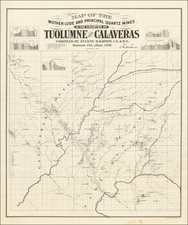
Rare early map of Redlands, California, prepared by Isaac Ford and printed by Britton & Rey in San Francisco.
The present map is likely the first printed map of Redlands, published only 2 years after its incorporation. OCLC lists only this map (known in 1 copy, at the Huntington Library) and a map of 1897 (again known in only 1 example).
The map shows a fantastic early snapshot of Redlands, with subdivisions already extending into Redlands Heights. The map also identifies a number of early land owners and names the major subdivisions and tracts. The annotations in Red, Green and Pink are annotations added by an Engineer of either the Pacific Electric Railway Company or the Southern Pacific Railroad. The map comes from a collection of SPRR maps de-accessioned by the SPRR in the early 1980s, which included a large archive of Pacific Electric Railway maps. At the far right, there are a numer of pencil annotations, discussing the choice of possible route for street car lines near Redlands Street and Creaft Avneue.
The map was prepared by Civil Engineer Isaac Ford, a prominent Redlands pioneer, for whom Ford Park and Ford Avenue are named. The map includes two smaller maps, one showing the local school districts (Lugonia, Crafton, Redlands and Railroad) and a second map of Southern Californi, showing the location of the city. The Santa Ana River And Wash are prominently shown, along with Hewitt's private Ditch, which connected the south fork of the river to Hewitt's farming tracts. The line of the Southern Pacific Railroad can be seen coming from the west (San Bernardino), with a second line following along Citry Avenue, coming in from Colton through Barton Ranch. In the south, the roads into San Timoteo Canyon can be been, along with roads to Beaumont and Banning. Allessandro is already shown headed south from Hillside Cemetary into the Canyon.
Once part of the Spanish Mission lands, Redlands was incorporated in 1888 following an influx of wealthy easterners and mid westerners. Redlands was the shared dream of Frank E. Brown, a civil engineer and Yale graduate, and E. G. Judson, a New York stock broker, who met in Southern California in late 1870's.
One group of early settlers called itself the Chicago Colony and created what is now the downtown business district. They named the principal shopping street for State Street in Chicago. In 1889, twins Alfred H. and Albert K. Smiley came to Redlands. The Smiley brothers, well known educators and resort owners from New York, established a tradition of philanthropy with their donation of the A. K. Smiley public library and park in 1889.

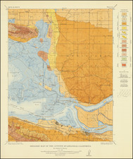
![[ Imperial County / Annotated by County Surveyor ] Denny's Pocket Map of Imperial County](https://storage.googleapis.com/raremaps/img/small/87140.jpg)
![[Drake's Bay to Fort Bragg] Bodega Head to Abalone Point From The Latest United States Government Charts . . .](https://storage.googleapis.com/raremaps/img/small/73078.jpg)