|
||

|

|
|

|
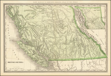
Rare map of showing the Northwest Passage, via the Bering Straits, with a fantastic early depiction of Alaska (then Russian America) and contiguous parts of Canada.
Philip's map highlights the discoveies of Franklin and Richardson in the Arctic Sea (1825-26), one of hte few maps to provide a detailed treament of this part of the coastline of Alaska and Canada. The detail in the interior is also of interest, especially the identification of Canadian Indin Tribes on either side of the MacKenzie River.
The course of the Youcon (Yukon) River and Colville River are shown in the interior of Alaska, although relatively little else was known at the time.
While the coastline of Alaska is quite well depicted, there are still a number fair number of areas marked with dotted lines or otherwise inaccurately mapped.

![[To The Alaska Gold Fields] Map of Fairbanks Mining District](https://storage.googleapis.com/raremaps/img/small/65950.jpg)
![[Alaska to San Diego and San Qunitin, British Columbia] A Chart Shewing Part of the Coast of N.W. America, with the Tracks of His Majesty's Sloop Discovery and Armed Tender Chatham . . . (First Modern Map of the West Coast of North America)](https://storage.googleapis.com/raremaps/img/small/102067.jpg)