|
||

|

|
|

|
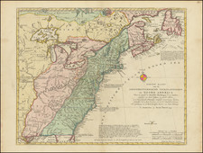
Scarce1783 variant of Latte's 2-sheet map of the United States, published in Paris.
The 1783 edition of Lattre's map is one of the first printed maps to include the name United States ("Etats-Unis") in the title. First published in 1771, the map initially had the words "La Nouvelle Angleterre" (New England) in the title, which is replaced with "Etats-Unis" in the 1783 edition.
The map was updated in 1776, with the second state of the map showing "Theatre de la Guerre en Amerique" at top of sheet.
The first state of the map is typically found bound as two separate maps in the Atlas Moderne. Ashley Baynton Williams states in Mapforum that an edition of 1762 exists, but we believe this is in error. Ashley Baynton Williams suggests that two states of the 1783 edition exist, with the difference being that the second edition includes the name United States in an abbreviated title above the top neat line of the lower sheet (a difference which would not be observable in a joined example).
The present example was joined and colored before being bound into a composite atlas and includes fin original hand coloring. While the individual sheets do appear on the market occasionally, we have not previously seen an example of the 1783 edition of the map joined in the 18th Century and in full original color.
Jean Lattré (fl. 1743-1793) was a Parisian bookseller and engraver who published many maps, plans, globes, and atlases. He worked closely with other important French cartographers, including Janvier, Bonne, and Delamarche, as well as other European mapmakers, such as William Faden, Santini, and Zannoni. Lattré is also interesting due to his propensity to bring suits against those who copied his work; plagiarism was common practice in eighteenth-century cartography and mapmakers struggled to maintain proprietary maps and information.
![[ French & Indian War Battle Plan--Louisbourg ]. Plan De Louisbourg...](https://storage.googleapis.com/raremaps/img/small/57192.jpg)