|
||

|

|
|

|
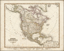
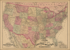
Rare 6 sheet map of the United States by J.L. Sanis, published by Erhard in 1862. For the dating of the map, we are relying upon a catalogue entry in the Bibliotheque Nationale de France and the dating of the 2 recorded examples (British Library and BNF).
The map shows a fantastic depiction of the Western United States, pre-dating the creation of Arizona Territory, Nevada and Colorado Territories, and still showing massive Nebraskas Territory, including all of the area which would become Wyoming Territory and Montana Territory. Several interesting early Territorial capital cities are shown, including Fillmore City, Utah. A number of important early roads in the west are also located.
Jean Leon Sanis seems to have flourishedfrom 1854 to 1861, when he and Delalleau de Bailliencourt published the Geographie historique de la France. Atllas Special. The atlas was published for Napoleon III and was critical of the preceding governments. Most notably, the text opposite the map of France under Louix XVIIII, Charles X, Louis-Philippe and the Second Republic (1815-1848) claimed that these regimes had not tried to modify the erms of hte Congress of Vienna, terms that it alleged humiliated France. In addition, the atlas offered evidence of France's heroic and successful past.
It is quite possible that the map was prepared several years earlier, as the sole source for dating the map appears to be a catalogue entry in an old journal, which may not necessarily reflect the first date of of publication.
OCLC locates 2 examples of the map (British Library and Bibliotheque Nationale de France). No copies in American institutions.
![[School Girl Map] United States by Betsey C. Converse](https://storage.googleapis.com/raremaps/img/small/66109.jpg)