


|
||

|

|
|

|
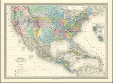
Excellent large format map of the US & Canada, showing tremendous detail, especially in the west. The map includes a large rendition of Deseret oder Utah, a reference to the unsuccessful attempt to create a Mormon state of Deseret. The map also includes a bizarrely shaped California, pre-Gadsden purchase border with Mexico, Nebraska Territory extending to Canada, Oregon Territory extending to the Rockies, and oddly shaped Texas and New Mexico. The details of the map in Texas are excellent, showing the German Colony, N. Braunfels, Friedrichsberg, the Alt Spanish Fort, and dozens of early towns and place names. The map illustrates dozens of Indian Names, early roads through the west, and other important features. The detail on either side of the Canadian Rockies is also excellent. One of the most interesting maps of the period following the conclusion of the Mexican War.

![[ English Plantations in North America ] A New Map of the most Considerable Plantations of the English In America Dedicated to His Highness William Duke of Glocester.](https://storage.googleapis.com/raremaps/img/small/98233.jpg)