|
||

|

|
|

|
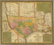
Fourth edition of David Burr's map of Texas, upated for the first time since the publication of the third edition in 1835.
The map was ultimately published in 5 editions, 1833, 1834, 1835, 1845 and 1846. The first 3 editions of the map were published by J.H. Colton in New York. This 4th edition was the first published by R.S. Fisher, although retaining S. Stiles & Co as the map engraver. In this 1845 edition, there are a number of improvements made which were not present in the earlier editions. A key notes the delineation of State lines, County Lines, Patent Lines and Roads. Many new counties are shown, super-imposed over the old Empresario Grants, and number of new towns appear, making the map a fantastic amalgam of new information from 1833 to 1845.
The map includes manuscript annotations focused on the lands originally offered "for sale" by the Galveston Bay Company, which are circled in orange and the name underlined, along with Zavalla's Grant. The Neu Braunfels Germany colony is added in manuscript, with two other annotations, one on either side.
The map was originally owned by John C. Ernenputsch, a German businessman based in New York. Longworth's Almanac of 1839 lists Ernputsch as an importer and was acquired from the heirs of Ernenputsch, who now reside in Denmark, along with a number of other Texas related documents.
It would seem that at some early date, Ernenputsch became interested in investing in Texas real estate, and may have been considering relocating to Texas. The small archive of his documents which were included in his papers includes a Dominguez Grant and Galveston Bay Land Company scrip. Ernenputsch did in fact wind up purchasing scrip from the Galveston Bay Land Company and apparently spent most of the next 20 years trying to collect on his investment.
Ernenputsch is mentioned by George Scherpf in his Appeal to the public; or, A story without fiction, but with some villains, and a Victim, who is the Author Thereof, Containing the Miscarried Transformation of E. F. Meisel of Prague, into E. L. Von Szadeczky of New York . . . (1851). Scherpf tells a story of the Meisel, aka Von Szadeczky, a con artist who arrived in New York in 1845.
The Congressional Record for 1857 notes that Ernenputsch as paid out on "Treasury Texas Warrants" in the 2nd Quarter of 1856.
E. F. Meisel arrived here on board the ship Hercules, from Constantinople, on the 8th of January, 1845, with a letter of introduction to Mr. J. C. Ernenputach, a German merchant here, from his correspondent at Constantinople, which represented him as one Edward Ladislaus yon Szadeczky, a Hungarian. The account which he gave of himself was a strange combination of lies and facts; calculated to hide what he wished to conceal, and yet clumsily contrived.
Scherpf, Ernenputsch and several other German businessmen were apparently conned by Meisel into loaning him money and investing in a joint stock company that went poorly for the investors. There is no indication that this enterprise had any connection with either Scherpf's or Ernenputsch's interests in Texas.
Our search of the auction records reflects that no copies of the 1845 edition of the map have appeared at auction in over 50 years, with the 1846 edition last appearing at auction in 2001.
David H. Burr studied law, passing the New York Bar Exam, and then surveying under Simeon DeWitt in New York. His first atlas was an atlas of New York State (1829), the second state atlas to be issued in the US (after Mills’ Atlas of South Carolina in 1826). In the 1830s, he served as the official topographer for the US Post Office, producing a series of rare and highly sought-after large-format state maps. He also created a map of the country’s postal routes, which features roads, canals, and railroads. Burr traveled to London to work with John Arrowsmith; together, they produced the American Atlas in 1839.
Upon his return to the States, Burr was appointed as a draftsman for the House of Representatives, where he worked until ca. 1841. He later worked for the Louisiana Survey and the Florida Survey. By 1850, he was back in Washington D. C., working on the census. In 1852, the Senate named Burr as the draftsman to compile maps from the Federal Surveys. In 1853, Burr traveled to San Francisco, perhaps as part of his work for the Senate. He was then named as the Surveyor General of Utah in 1855. However, he was unpopular there and returned to Washington D. C. by 1870. Burr is widely regarded as one of the most important names in the nineteenth-century American history of cartography.
![Carte De La Louisiane Et Du Cours Du Mississipi . . . Juin 1718 [1st State!]](https://storage.googleapis.com/raremaps/img/small/59797.jpg)