


|
||

|

|
|

|
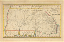
Extremely rare map centered on the Gulf of Mexico, illustrating the region in conflict among the French, Spanish & English, during the American Revolution.
While the American Revolution's primary battlefronts were in North America, the strategic importance of the war in Europe was also focused on control of strategic islands in the Caribbean. The map shows the theatre of war on a Caribo-Centric basis, with large insets of the islands of Dominique, St. Vincent, Grenadine and Jamaica.
Florida is shown as an archipelago, with a fantastic river traversing from northeat to southwest. A forts are located in the South.
We note a copy referenced in Mapoteca Columbiana, but have not located any other examples.
Louis Denis (1725-1794) was a French geographer and cartographer best known for his incomplete road atlas of France, Le Conducteur français. Originally trained as an engraver, he partnered with Louis-Charles Desnos to create and edit maps. Later, Denis served as geography tutor to the children of the French royal family. His pupils included the Duc de Berry, the future Louis XVI.


![[ Florida Indians ] Ceremonia a Saturioua in expeditionem adversus hostes profecturo, observatae. XI](https://storage.googleapis.com/raremaps/img/small/86474.jpg)